• MAIN PAGE
  • LATEST NEWS
    • Lost Cities
    • Archaeology's Greatest Finds
    • Underwater Discoveries
    • Greatest Inventions
    • Studies
    • Blog
  • PHILOSOPHY
  • HISTORY
  • RELIGIONS
    • Africa
    • Anatolia
    • Arabian Peninsula
    • Balkan Region
    • China - East Asia
    • Europe
    • Eurasian Steppe
    • Levant
    • Mesopotamia
    • Oceania - SE Asia
    • Pre-Columbian Civilizations of America
    • Iranian Plateau - Central Asia
    • Indus Valley - South Asia
    • Japan
    • The Archaeologist Editor Group
    • Scientific Studies
    • Aegean Prehistory
    • Historical Period
    • Byzantine Middle Ages
    • Predynastic Period
    • Dynastic Period
    • Greco-Roman Egypt
  • Rome
  • PALEONTOLOGY
  • About us
Menu

The Archaeologist

  • MAIN PAGE
  • LATEST NEWS
  • DISCOVERIES
    • Lost Cities
    • Archaeology's Greatest Finds
    • Underwater Discoveries
    • Greatest Inventions
    • Studies
    • Blog
  • PHILOSOPHY
  • HISTORY
  • RELIGIONS
  • World Civilizations
    • Africa
    • Anatolia
    • Arabian Peninsula
    • Balkan Region
    • China - East Asia
    • Europe
    • Eurasian Steppe
    • Levant
    • Mesopotamia
    • Oceania - SE Asia
    • Pre-Columbian Civilizations of America
    • Iranian Plateau - Central Asia
    • Indus Valley - South Asia
    • Japan
    • The Archaeologist Editor Group
    • Scientific Studies
  • GREECE
    • Aegean Prehistory
    • Historical Period
    • Byzantine Middle Ages
  • Egypt
    • Predynastic Period
    • Dynastic Period
    • Greco-Roman Egypt
  • Rome
  • PALEONTOLOGY
  • About us

“Denny,” the Denisovan–Neanderthal Girl: why one small bone changed the story of our mixed human past

August 16, 2025

In 2012, archaeologists sifting through thousands of unidentifiable bone scraps from Denisova Cave in Siberia pulled out a sliver no bigger than a thumb tip. It had no diagnostic shape and no context beyond the layer it came from. Yet that fragment—catalogued as Denisova 11 and later nicknamed “Denny”—turned out to be one of the most extraordinary individuals ever sequenced: a first-generation child of a Neanderthal mother and a Denisovan father. In one genome, Denny compresses the messy, braided history of archaic humans into a single life story. (eva.mpg.de)

From anonymous scrap to headline fossil

Denny was not discovered because of how the bone looked but because of how its proteins and DNA read. A team led by Samantha Brown first screened the cave’s bone splinters with ZooMS (Zooarchaeology by Mass Spectrometry), a “collagen fingerprinting” method that flags likely hominin pieces among animal remains. That test picked out Denisova 11 as human. The group then sequenced its mitochondrial DNA (mtDNA) and found it belonged to a Neanderthal lineage; radiocarbon tests placed the fragment at more than 50,000 years old—beyond the reliable limit for precise ^14C dates but clearly Late Pleistocene. (PMC)

Subsequent nuclear-genome work at the Max Planck Institute for Evolutionary Anthropology clinched the shock finding: across Denisova 11’s chromosomes, the pattern of variants alternated cleanly between Neanderthal and Denisovan alleles, exactly what you expect in an F1 (first-generation) offspring. The researchers could also tell that her mother belonged to a Neanderthal population genetically closer to later European Neanderthals than to earlier Altai Neanderthals from the same cave—evidence for Neanderthal movements across Eurasia—and that her Denisovan father carried traces of deeper Neanderthal ancestry in his own past. In other words, not only were Neanderthals and Denisovans meeting; they were meeting more than once. (eva.mpg.de, mpg.de)

How old was Denny when she died? The fragment’s cortical thickness and histological features point to an adolescent—at least 13 years old. It’s a small, human detail in a genome-scale story. (PMC, mpg.de)

Why she’s (still) the only one of her kind

Geneticists have long known that archaic humans mixed. Non-African people today carry Neanderthal DNA; populations from parts of Oceania and Southeast Asia carry Denisovan DNA as well. But those are echoes—signals of ancient interbreeding diluted by tens of thousands of years of recombination. Denny is different. She isn’t a statistical signature; she is the event. As of today, she remains the only confirmed first-generation Neanderthal–Denisovan individual ever identified, and she shows this mixing happened not just sporadically in deep time but in specific families who lived and died together. (eva.mpg.de)

That uniqueness reflects more than biology; it reflects sampling. Ancient DNA research depends on the luck of preservation, the happenstance of excavation, and the ingenuity of screening methods. Denisova Cave has been extraordinarily kind in this regard. Even so, Denny exists for us because a proteomics screen pulled her out of anonymity and because her DNA survived well enough for high-coverage analysis. Her status as “the only one” is a reminder that the fossil record is patchy and biased—which makes every “data point” like this disproportionately valuable. (PMC)

A braided landscape: when and where did groups meet?

Denny’s home ground helps explain the opportunity for encounters. Denisova Cave sits in the Altai Mountains at a crossroads between western and eastern Eurasia. Optical dating of the site’s sediments shows that Neanderthals, Denisovans and later Homo sapiens used the cave across hundreds of thousands of years, with occupations spanning roughly 300,000 to 20,000 years ago. This extended, overlapping presence created repeated chances for contact. (Nature)

More recently, sediment DNA studies have mapped these comings and goings even when bones are absent. A 2021 project sampled 728 sediment spots through the cave’s chambers and recovered ancient mitochondrial DNA from animals and hominins. The results chart turnovers in Denisovan and Neanderthal presence and show that both groups repeatedly occupied the cave—well into the time windows when initial Upper Palaeolithic technologies and modern human mtDNA first appear in the record. That broader picture makes Denny less a one-off curiosity and more a vivid snapshot from a long-running frontier of contact. (Nature)

What one genome tells us about two populations

Because Denny is an F1, her genome acts like a two-for-one archive. On her mother’s side, affinities to European Neanderthals imply east–west mobility among Neanderthal groups long before their disappearance. On her father’s side, the trace of older Neanderthal ancestry shows that Denisovans had already mixed with Neanderthals earlier—a layered history of contact that likely played out multiple times. The striking probability calculation from the original study is almost philosophical: among the tiny number of archaic individuals sequenced so far, to happen upon a literal first-generation hybrid suggests that, whenever these groups overlapped in space, interbreeding was not rare. (eva.mpg.de)

Methods that made the discovery possible (and why they matter)

Denny’s story is also a methods story. ZooMS triage turns “undiagnostic” bone crumbs into candidates for DNA work, making the most of sites where hominin remains are scarce or fragmentary. Pairing that with both mitochondrial and nuclear DNA analysis lets researchers separate maternal lineage (mtDNA) from the full ancestry picture (nuclear genome). This workflow—proteins to flag, mtDNA to place, nuclear DNA to resolve—has become a template for pushing the limits of what tiny fragments can tell us. Without it, Denisova 11 would still be a nameless shard in a storage tray. (PMC)

Why Denny matters beyond Denisova

First, she personalizes admixture. It’s one thing to say “Neanderthals and Denisovans mixed.” It’s another to read the genome of a teenager whose parents belonged to those different groups. That personalization helps the public grasp that human evolution is not a tree of neatly separated branches but a network of lineages exchanging genes when they met.

Second, she’s a calibration point. Denny anchors hypotheses about when and where Neanderthals moved across Eurasia and how often Denisovans and Neanderthals interacted. Her genome independently supports an east–west Neanderthal connection and a multi-episode contact history between Neanderthals and Denisovans—insights that would be far harder to extract from modern DNA alone. (eva.mpg.de)

Third, she contextualizes the cave’s deep-time narrative. Chronologies and sediment aDNA show that Denisova was a long-term meeting ground with shifting occupants and ecologies. Denny’s existence during that sequence makes the broader patterns tangible: overlapping ranges, intermittent contact, and cultural horizons in flux. (Nature)

Finally—and this is my take—Denny stands as a methodological milestone. She demonstrates that with careful screening and high-coverage sequencing, even “invisible” fragments can transform our models. If one F1 hybrid appears in such a small sample, the real history was likely rich with similar families whose traces are still waiting in museum drawers and sediment grids. That prospect is exhilarating because it promises a more nuanced, human-scaled story of how different groups met, lived, and sometimes had children together.

References (selected)

  • Slon, V. et al. (2018). The genome of the offspring of a Neanderthal mother and a Denisovan father. Nature 561, 113–116. (Open-access PDF). (eva.mpg.de)

  • Brown, S. et al. (2016). Identification of a new hominin bone from Denisova Cave, Siberia using collagen fingerprinting and mitochondrial DNA analysis. Scientific Reports 6, 23559. (Open-access). (PMC)

  • Jacobs, Z. et al. (2019). Timing of archaic hominin occupation of Denisova Cave in southern Siberia. Nature 565, 594–599. (Nature)

  • Zavala, E. I. et al. (2021). Pleistocene sediment DNA reveals hominin and faunal turnovers at Denisova Cave. Nature 595, 399–403. (Nature)

  • Max Planck Institute press release (2018). Neandertal mother, Denisovan father! (summary with age estimate and population affinities). (mpg.de)

In Paleontology Tags D

The Limestone Icarus Memorial of Poland: Nazi Ambition Carved in Stone

August 11, 2025

Hidden in the quiet corners of the world are places where the past still whispers—sites that seem torn from the pages of a legend. Yet in this case, the magic of the landscape was overshadowed, its timeless aura pressed beneath the iron discipline and polished boots of Nazi Germany.

In the gentle but geologically rich landscape of Poland’s Opole region, there lies what was once considered "white gold": Triassic limestone, a geological treasure created some 252 to 201 million years ago. Local quarries extracted this limestone for generations due to its versatile applications—from building materials to agricultural uses. Its nickname, “white gold,” hints at its economic value, but beneath that sheen lies a darker, more enigmatic chapter.1

One such chapter plays out on the slope of Stone Mountain (Kamienna Góra), near the modest village of Ligota Dolna, where a long-abandoned lime kiln still stands (Wapiennik Ikar). Though it ceased functioning in 1994, the structure remains a ghostly silhouette against the sky—a monument to far more than industrial history.

Icarus Reimagined—From Myth to Propaganda

Embedded upon one wall of that kiln is a peculiar bas-relief: a rendition of Icarus, that tragic Greek figure who soared too close to the sun and plummeted into the sea. Yet this version isn’t about hubris or the tragic consequences of over-ambition; it’s been hijacked and transformed. Surrounding Icarus is the emblem of the National Socialist Flyers Corps, or NSFK—a paramilitary Nazi aviation group. Though the swastika that once accompanied it has since been deliberately removed, telltale metal hooks and faint traces remain, ghosts of symbols erased from sight but not memory.

That uneasy combination—a subject drawn from ancient Greek myth, turned into a Nazi logo, carved into a limestone kiln—captures a surreal collision of epochs: Mesozoic geology, Hellenic mythology, and totalitarian propaganda. All layered upon one weathered wall.

The NSFK, Gliding Training, and Count Sierstorpff’s Legacy

The larger context of this emblem’s presence becomes clearer once you examine Ligota Dolna’s aviation history. In the mid-1920s, the region’s noble—Count Sierstorpff of Żyrowa—established a glider training school known as the Segelfliegerheim Oberschlesien. Pilots learned to navigate the skies using only gliders, well before the Second World War.

By the 1930s, glider schools were increasingly linked with Nazi paramilitary organizations, including the NSFK, which formed in 1937. Its mission was ostensibly aviation training—but behind the scenes, it served as semi-formal preparation for Luftwaffe service, replete with ideological grooming alongside technical instruction.

In Ligota Dolna, two airstrips existed: an “upper” field, used until 1944, and a “lower” one built later for advanced flight training. Local legend—unsubstantiated by official documents—speaks of a tragic incident: a glider pilot crashing into the kiln’s wall. Whether or not the fatality truly happened as told, in 1938 the kiln was repurposed as a memorial. It became a gladiatorial hybrid: myth of Icarus fused with Nazi symbolism, engraved with the date 1938, a cross, and the initials “SM.” The tragedy—real or symbolic—was immortalized in stone.

A Calculated Mythologizing of Greek Antiquity

What we witness here is more than local lore; it’s emblematic of a broader Nazi pattern: the appropriation of Hellenic and classical motifs to legitimize their ideology. The Third Reich courted imagery drawn from antiquity—heroic figures, mythic ideals, classical architecture—to suggest alignment with supposed Aryan inheritance.

Icarus, traditionally a cautionary tale—even a rebuke of overreaching ambition—was reshaped. In the Nazi appropriation, Icarus becomes youthful hero, valiant flyer, aspirant to transcendence, devoid of moral lesson. Rather than warning against overreaching, the symbol encouraged it—an aestheticized hubris that fit neatly within the militaristic glorification of youthful risk, sacrifice, and the conquest of physical and ideological boundaries.

Thus, the kiln becomes not just a local memorial, but a stage upon which myth and propaganda collide, anchored in stone and history.

1939: Bombers, Blood, and the Opening Shots of War

If the kiln anchored myth in stone, the nearby airfields were the real launching pads of modern tragedy. On September 1, 1939, dive bombers—likely Junkers Ju 87 Stukas—took off from this very airfield and struck the nearby town of Wieluń. That bombing preceded even the famed cannon shot fired at the Polish garrison in Westerplatte. In other words: the war, at least in terms of aerial destruction, began here, before most textbooks point to any official military engagement.

The narrative of the war’s "beginning" becomes distilled and condensed in the public imagination, yet here lies a reminder: history is messier, blurrier, and far more human. This neglected kiln and faint Icarus remind us that monumental shifts of history can trace their origins to obscure places.

Limestone, Memory, and the Weight of History

There is something poetic, almost cruel, in the ironic nature of this site. A kiln meant to produce lime—turning something ancient into building material, mortar, fertilizer—becomes a memorial to ideological ambition. The geological past is suspended alongside myth, propaganda, and memory.

The swastika may have been removed, but is that erasure a triumph or an evasion? The kiln stands in near-silence, its relief worn, the initials fading, and the swastika gone. Yet, hooks still remain—silent witnesses to what was. And that presence, though subdued, insists that we remember.

The kiln was closed in 1994, rather late in the context of Eastern Europe’s post-Cold War transformations. Since then, the site has dwelled in neglect, overseen by time, vegetation, and quiet erosion. Today, few visitors make the pilgrimage—yet for those who do, the place evokes a dense layering of time: from the Triassic seas to Greek myth, from interwar glider flights to Nazi memorialization, and finally to the present, where memory and decay intersect.

Reflecting on Ideology, Heritage, and the Past

This kiln is not just a historical oddity. It is a poignant reminder of how the past gets weaponized: how myth can be co-opted, how geology and industry can become a backdrop for ideological spectacle, how symbols can be stripped down, reshaped, and re-deployed.

We must ask ourselves: what does it mean when a culture’s mythic heritage is commandeered to serve a radical ideology? And what does it tell us about our own times, when symbols are contested, repurposed, or erased?

The limestone, in its geological silence, outlives human stories. Icarus falls again and again, but the rock endures. The Swastika may vanish, but the hooks remain. The airfield may lie reclaimed by grasses, but the memory of those first bombs lingers in the air.

VIII. Conclusion: Poetry and Politics in Stone

What remains, ultimately, is layered. The kiln is more than limestone; it is an archaeological artifact of ideology. It asks us to peer into silence and to hear echoes: of myth, supremacism, ambition, tragedy—even forgotten accidents or rumors.

The Nazi Limestone Icarus of Poland invites us to pause, and wonder: who gets to write myth? Who is allowed to soar, and whose wings are melted by politics? The kiln cries out softly—and that voice, though ancient and weathered, is vital.

Tags D, The Archaeologist Editorial Group

10 Overlooked but Unforgettable Archaeological Sites in Greece to Explore This Summer

August 9, 2025

Greece is a land where history is never far from view — yet beyond the famous names like the Acropolis, Delphi, and Olympia lies another world of ancient wonders, quieter and often overlooked. Scattered across islands, mountain valleys, and fertile plains are archaeological sites that once thrived with commerce, worship, athletic contests, and everyday life. Many remain blissfully free of the crowds, offering the rare chance to wander through ruins in near solitude while the landscapes that shaped them stretch out around you.

This summer, whether you’re island-hopping or road-tripping through the mainland, make time to step off the beaten path. The following 10 sites may not dominate guidebook covers, but each holds stories, artistry, and atmosphere that can rival — and sometimes surpass — Greece’s most famous monuments.


1. Ancient Karthea (Kea) — A Stunning Blend of Landscape and History

photo source: Europa Nostra

Karthea, located on the southeastern coast of Kea, was one of the island’s four powerful, autonomous city-states, continuously inhabited from the Geometric period (8th century BC) until the mid–Late Antiquity (6th century AD). It stands out for its remarkably preserved ancient harbor: a submerged port about 525 feet (160 m) long and 115 feet (35 m) wide, built from stone and gravel, still visible between two coves.

Reaching this historic site requires a hike (or a sea route), which adds an adventurous touch and an authentic sense of exploration. The most popular trail begins at Stavroudaki and takes about an hour, so be sure to bring water, a hat, and sturdy footwear. This is a rare blend of pristine natural beauty, historical memory, and conscious archaeological preservation, brought to light through careful scholarly work.

Among the ruins, you’ll find the foundations of the Doric Temple of Athena and the Archaic Temple of Apollo (Pythion), both clear markers of the city’s religious life, social cohesion, and artistic development. The remains of the old fortification system — at least six gates, defensive towers, and public buildings — testify to an organized administration, water supply infrastructure, workshops, and possibly even quarrying activities. Karthea is one of those rare places where nature and history remain inseparably intertwined.


2. Delos — The Radiance of Greek Classical Heritage

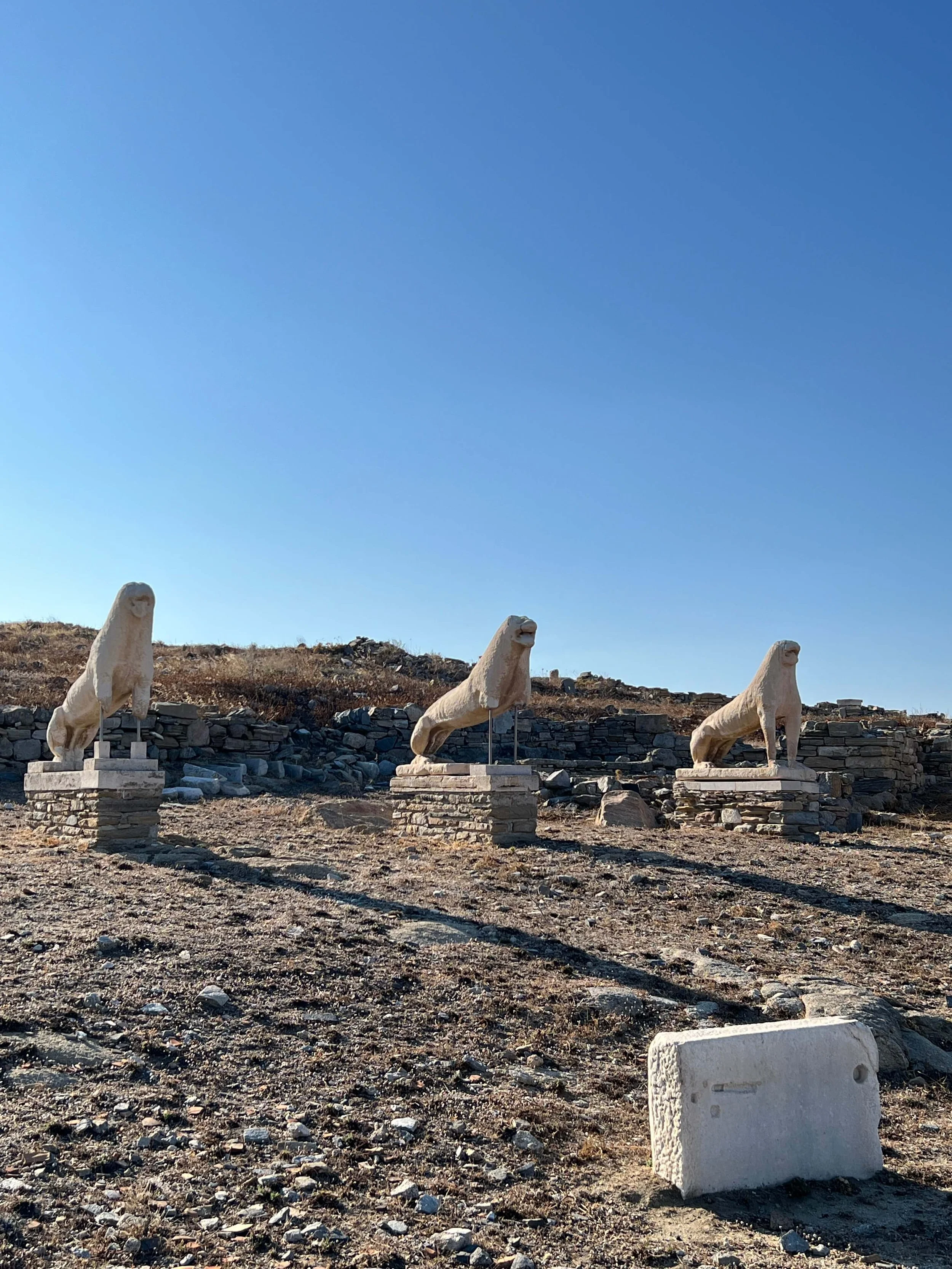
Delos, a UNESCO World Heritage Site since 1990, is considered one of the richest and most extensive archaeological sites in the Mediterranean. Regarded in antiquity as a sacred island, it was the mythical birthplace of Apollo and Artemis, and it flourished in the 5th century BC when Athens established the treasury of the Delian League there.

Today’s visitors can walk among temples, statues, plazas, and marketplaces such as the Agora of the Competaliasts, once a bustling commercial center adorned with marble monuments dedicated to Hermes. In its prime, it was lined with shops and monuments funded by merchants and bankers from across the ancient world.

Particularly striking are Delos’ exceptional mosaics from the Hellenistic period (late 2nd–early 1st century BC), which account for about half of all surviving mosaics from that era. They showcase both geometric and naturalistic patterns, crafted using the opus tessellatum and opus vermiculatum techniques.

The Temple of the Delians, a Doric peripteral temple originally financed by Delos and the League, reflects the island’s religious grandeur. Although damaged during the Mithridatic Wars, its foundations and traces of its columns still stand.

Uninhabited since the 7th century AD, the island’s isolation has preserved its archaeological remains in remarkable condition, offering an almost untouched snapshot of a thriving ancient cosmopolitan center just a short boat ride from Mykonos.


3. Ancient Messene — A Masterpiece of Classical Urban Design

Columns by the stadium at Ancient Messene, with the Grave Monument visible near the end. Peulle

Nestled in the heart of the Peloponnese, Ancient Messene is one of the best-preserved cities of classical antiquity, founded in 369 BC by the Theban general Epaminondas after the Battle of Leuctra. It served as the capital of the newly liberated Messenian state, complete with impressive fortifications stretching nearly six and a half miles (10 km), which remain among the most complete defensive walls of ancient Greece.

What makes Messene extraordinary is its sheer scale and the quality of preservation. Visitors can wander through the ancient theater, which once seated thousands and hosted both dramatic performances and political gatherings. The Asclepeion (healing sanctuary dedicated to Asclepius) offers a glimpse into ancient medicine, with surrounding stoas that once bustled with pilgrims seeking cures.

The city plan follows the Hippodamian grid, reflecting an advanced approach to urban planning. Public fountains, gymnasia, and sanctuaries were carefully integrated with residential areas, and the agora served as the vibrant heart of civic life. Walking its streets feels like stepping directly into the 4th century BC — yet without the massive tourist crowds found in more famous sites like Delphi or Olympia.


4. Ancient Corinth — Gateway Between Two Worlds

The remains of the archaic temple of Apollo, Corinth (550-530 BCE). Originally, there were 6x15 Doric monolithic columns. - Mark Cartwright

Situated on the narrow Isthmus of Corinth, this city was one of the most strategically important locations in the ancient world, controlling trade between mainland Greece and the Peloponnese. Its history stretches from the Neolithic era through the Roman period, with layers of monuments revealing a cosmopolitan past.

Dominating the site is the Temple of Apollo, a 6th-century BC Doric structure whose stout limestone columns still stand in stark beauty against the sky. Corinth was famed for its wealth, artistic production — especially Corinthian pottery — and for the Diolkos, a paved roadway that allowed ships to be transported overland between the Aegean and Ionian seas.

Above the ancient city rises Acrocorinth, a massive fortified hill that served as both a military stronghold and a sanctuary. From its heights, you can see the Corinthian Gulf on one side and the Saronic Gulf on the other — a reminder of why Corinth prospered as a hub of commerce and culture for centuries.


5. Ancient Kamiros (Rhodes) — A City Frozen in Time


Tango7174

On the northwestern coast of Rhodes, the archaeological site of Kamiros offers a rare, intact example of a Hellenistic city, abandoned not through war but by gradual decline. Established in the Geometric period and rebuilt after a 5th-century BC earthquake, Kamiros flourished as one of the island’s three principal cities alongside Lindos and Ialysos.

The site’s terraced layout is striking: the acropolis at the top, with the Temple of Athena Kameiras; the residential quarter in the middle; and the public spaces and fountain square below. Stone-paved streets and remnants of houses offer a tangible sense of daily life — from cisterns for water collection to storerooms for agricultural goods.

Unlike more monumental ruins, Kamiros feels intimate and human-scaled. Standing amid its quiet streets, with the sea visible in the distance, you can almost hear the bustle of a small but thriving port community that once traded with the wider Mediterranean.


6. Dodona — The Voice of the Sacred Oak

Author Marcus Cyron

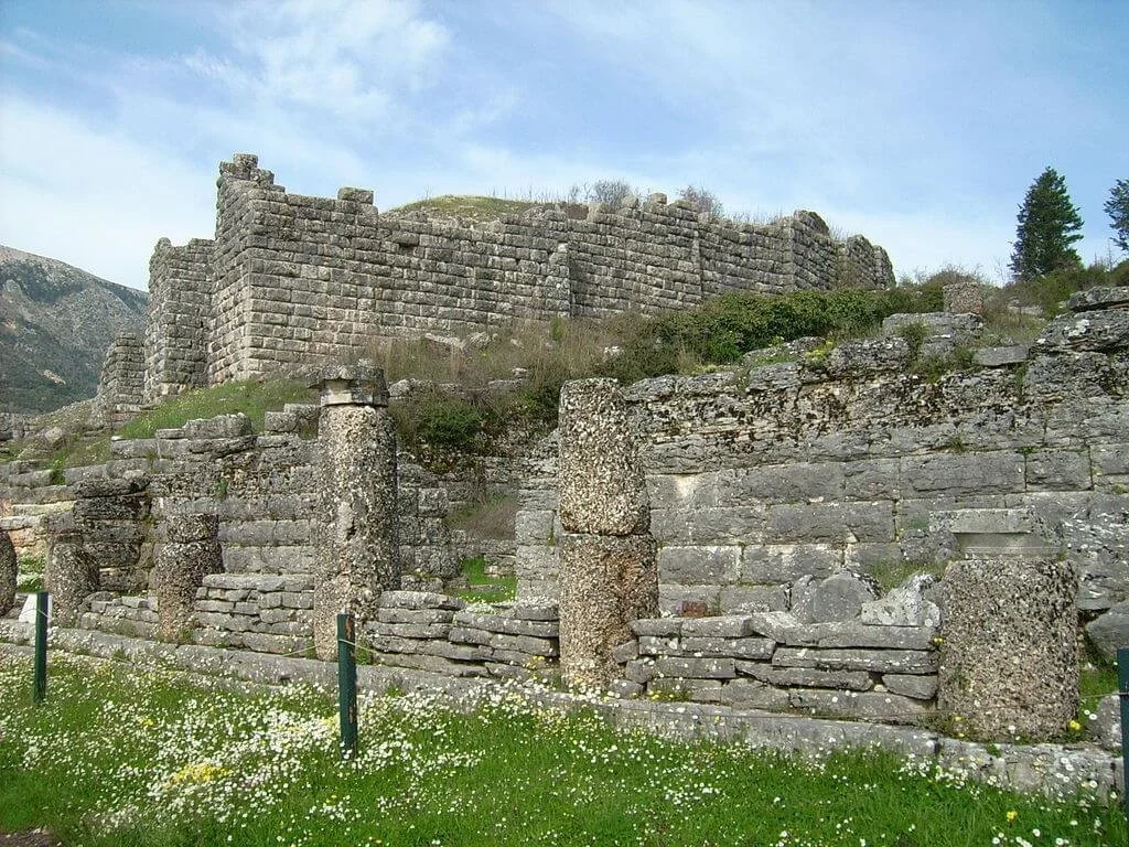
In the lush Epirus region, Dodona is one of Greece’s oldest oracular sites, predating even Delphi. Dedicated to Zeus and his consort Dione, it was famed for its unique method of prophecy: priests and priestesses interpreted the rustling of the sacred oak leaves and the sound of bronze cauldrons struck by chains in the wind.

The sanctuary flourished from the late Bronze Age and reached its peak in the 4th–3rd centuries BC under the Molossian kings. A monumental theater, capable of seating some 18,000 spectators, was later adapted for Roman gladiatorial games. Surrounding structures included temples to Zeus and Dione, stoas, and administrative buildings.

Today, Dodona retains a mystical quality — partly due to its remote, mountainous setting and partly because the site still seems to whisper ancient secrets. Visiting here feels less like ticking off a tourist destination and more like entering into a dialogue with the natural and divine forces that once shaped Greek spirituality.


7. Amphipolis — Mystery on the Strymon River

View of the Amphipolis Tumulus with the findings discovered on its southwestern side.
Photo: Hellenic Ministry of Culture

Located in Central Macedonia near the banks of the Strymon River, Amphipolis was founded by Athenians in 437 BC as a strategic stronghold to control the vital gold and silver mines of Mount Pangaion and the timber trade from the surrounding forests. It soon fell under Spartan, then Macedonian, and eventually Roman control, becoming a wealthy hub along the Via Egnatia.

The site gained global attention in 2014 when the enormous Kasta Tumulus burial mound was uncovered, revealing impressive marble sphinxes, caryatids, and intricate floor mosaics — sparking debates about the identity of the tomb’s occupant. While the tumulus itself is not yet open to the public, the surrounding archaeological area offers much to explore, including the famous Lion of Amphipolis, a monumental 4th-century BC sculpture that once stood at the city’s entrance as a symbol of power and prestige.

Strolling the ruins, you can trace remnants of the city walls, early Christian basilicas, and residential districts. Amphipolis holds a unique allure: part battlefield, part commercial center, part archaeological enigma, waiting for more of its story to emerge from the soil.


8. Ancient Lefkada — Echoes from the Ionian Past

While Lefkada is best known today for its beaches, the island also hides an ancient past. Archaeological evidence points to early settlements dating back to the Paleolithic era, with the most significant remains located near Nydri, associated with the prehistoric center possibly linked to Odysseus’ Ithaca in the theories of archaeologist Wilhelm Dörpfeld.

Visitors can explore the ruins of ancient fortifications, cyclopean walls, and sanctuaries dedicated to Apollo. The archaeological museum in Lefkada town complements the experience, displaying pottery, tools, and artifacts that reveal the island’s role in the Ionian trade networks.

Ancient Lefkada is not a sprawling site like Messene or Knossos — instead, it offers a mosaic of smaller discoveries set against the island’s lush scenery. For travelers willing to combine cultural exploration with seaside relaxation, it’s a perfect balance of past and present.


9. Knossos — The Labyrinth of the Minoan World

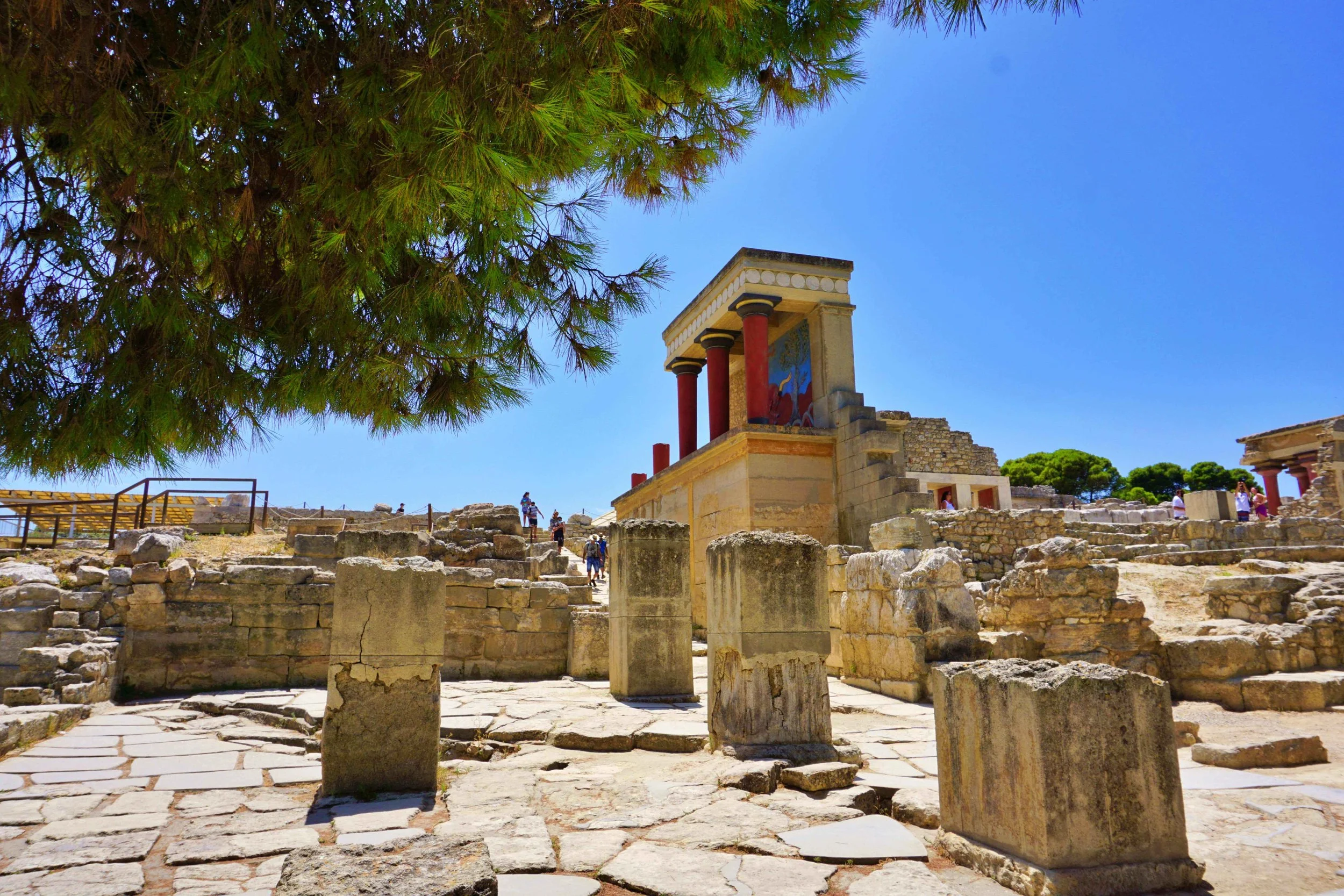
Just outside Heraklion in Crete, Knossos is the most famous Minoan palace and one of the most important archaeological sites in Europe. Occupied since the Neolithic period, it reached its peak between 1900 and 1450 BC, serving as the ceremonial and political center of Minoan civilization.

The palace complex is a maze of over 1,000 rooms connected by corridors — a design that may have inspired the myth of the Labyrinth and the Minotaur. Visitors can walk through reconstructed sections, including the grand staircase, the Throne Room, and the vibrant frescoes depicting dolphins, dancers, and ceremonial processions.

The site owes much of its current appearance to the controversial early 20th-century restoration work of Sir Arthur Evans, who used reinforced concrete to recreate parts of the palace. While debated among archaeologists, this reconstruction offers an evocative, if partly speculative, sense of the Minoan aesthetic.

Knossos blends myth, history, and archaeology in a way few places can, making it an unmissable stop for anyone seeking to understand the deep roots of Greek — and European — civilization.


10. Nemea — Where Myth Meets Athletic Glory

Author Ophelia2

Tucked in a peaceful valley of the northeastern Peloponnese, Nemea is best known from mythology as the lair of the Nemean Lion, which Heracles slew as the first of his twelve labors. But beyond legend, Nemea was also one of the four venues of the Panhellenic Games (alongside Olympia, Delphi, and Isthmia), attracting athletes, poets, and dignitaries from across the Greek world.

The archaeological site, active from the 6th century BC onward, centers around the impressive Temple of Zeus. Its towering limestone columns — three of which still stand in their original position — give a sense of the scale and solemnity of the sanctuary. Around it, you can trace the foundations of other sacred buildings and treasuries, as well as the ancient baths used by competitors before their events.

The nearby stadium, remarkably well preserved, includes a 600-foot (180-meter) track, stone starting lines, and the vaulted entrance tunnel through which athletes would enter, cheered on by spectators seated on grassy embankments. Walking through this tunnel, you get the uncanny feeling of following directly in the footsteps of ancient runners.

Today, Nemea remains quieter than Olympia or Delphi, yet its blend of myth, sport, and archaeology makes it one of Greece’s most atmospheric sites — especially during the modern revival of the Nemean Games, where visitors can participate in races on the ancient track barefoot, just as in antiquity.

Tags D, The Archaeologist Editorial Group

Rome Beneath the Waves: How Ancient Engineers Conquered the Sea

August 5, 2025

Two thousand years ago, the Roman Empire was not only dominating vast territories on land but was also achieving what to many seemed impossible—engineering feats beneath the surface of the sea. Without oxygen tanks, modern wetsuits, or high-tech diving gear, the Romans designed and built underwater structures that would challenge even 21st-century architects. From harbors constructed directly on the sea floor to experimental diving methods, their ingenuity continues to astound scholars and engineers alike.

This little-known chapter of Roman innovation reveals a civilization that was not only mastering roads, aqueducts, and monumental architecture—but also the depths of the ocean itself.

Diving Without Modern Equipment

The idea of underwater exploration in the ancient world conjures images of brave mariners and mysterious wrecks, but the Romans took it a step further—they developed rudimentary diving technologies to stay submerged for extended periods.

Historical accounts, notably from Pliny the Elder and later Byzantine sources, refer to “urinatores”—professional divers employed in both military and civilian roles. These divers salvaged sunken cargo, explored wreckage, and assisted in underwater construction. But how did they breathe?

The simplest technique involved using hollow reed tubes, extending from the diver’s mouth to the surface. While this method limited movement and depth (due to pressure constraints), it allowed them to stay submerged just long enough for short tasks. For deeper or more complex dives, the Romans may have used primitive diving bells—air-filled metal or clay containers inverted and placed over the head. Though rudimentary, these devices trapped enough air to allow a diver to descend up to 30 meters for short periods, according to some reconstructions.

While archaeological remains of these devices are scarce, literary and artistic evidence suggests such innovations were indeed part of Roman maritime operations. The ability to work underwater—however limited—was crucial to the Empire’s coastal infrastructure.

Lifting Giants from the Deep: The Port of Caesarea

One of the most astonishing Roman engineering feats is the artificial harbor at Caesarea Maritima, located on the coast of modern-day Israel. Commissioned by Herod the Great and completed around 10 BCE, this massive port demonstrates the Empire’s capacity to construct directly into the sea—a task that remains challenging for today’s builders.

Using massive concrete blocks molded and poured underwater, Roman engineers created breakwaters and seawalls that formed a fully functional harbor. These structures were laid atop submerged timber frameworks, filled with volcanic ash-based hydraulic concrete, and lowered into place with stunning precision. Divers and support crews had to coordinate these efforts while battling currents and visibility—a testament to their training and ingenuity.

The entire operation at Caesarea required logistical mastery, including quarrying materials, transporting them by sea, and assembling them underwater. The port served as a vital naval and commercial hub, connecting Judaea to the broader Roman trade network. Despite centuries of erosion, parts of the harbor remain intact, preserved in part by the remarkable properties of Roman concrete.

Concrete that Sets Underwater: Rome’s Hydraulic Masterpiece

Perhaps the single most significant Roman innovation that made these feats possible was their hydraulic concrete, known today as opus caementicium. While modern Portland cement crumbles in saltwater over time, Roman marine concrete has proven to be incredibly durable—even strengthening as it ages.

The secret lay in its unique composition: a blend of lime (calcium oxide), volcanic ash (pozzolana), and rubble or gravel. When mixed with seawater, this combination triggered a chemical reaction that produced calcium-aluminum-silicate hydrates, creating a rock-like bond. This allowed the concrete to set underwater, hardening quickly and bonding with the surrounding materials, including natural rock.

Modern scientists only recently unraveled the precise chemistry of this process, and studies published in journals such as American Mineralogist and Nature Materials have shown that the Roman mix is not only environmentally resilient but also self-healing—crystals continue to grow within cracks over time, strengthening the structure.

This discovery has profound implications for sustainable construction today. Several research groups are now looking to revive Roman concrete as a greener, longer-lasting alternative to modern cement, which is one of the largest industrial producers of CO₂ globally.

A Legacy Beyond Monuments

What makes Roman underwater engineering even more remarkable is that it was not confined to isolated cases. From Pozzuoli and Naples to Antibes and Alexandria, harbors, piers, and breakwaters constructed using the same principles stretched across the Mediterranean. These were not symbolic structures—they were functional lifelines for trade, military mobility, and urban development.

In some cases, Roman engineers also built submerged foundations for lighthouses, sea walls, and even fish tanks (piscinae) used in luxury villas. The tools and techniques they developed were systematic and adaptable, based on modular principles and transmitted across the Empire via military and administrative networks.

The broader philosophical implication is just as striking: Rome did not simply expand geographically—it expanded technologically, pushing the limits of what was possible in materials science, logistics, and the manipulation of nature. Their ability to “build the impossible” was a cornerstone of imperial identity and propaganda. For emperors like Augustus and Trajan, engineering marvels symbolized Rome’s destiny to tame the world—above and below sea level.

Reclaiming the Depths: Modern Insights from Ancient Mastery

Today, maritime archaeologists are increasingly aware of the sophistication of Roman underwater works. Dive surveys at Caesarea, Baiae, and other coastal sites continue to reveal foundations, mortar samples, and even wooden pilings preserved in anaerobic seabed conditions.

Meanwhile, collaborations between scientists and classicists have helped re-contextualize Roman maritime practices. Using AI, 3D scanning, and chemical analysis, we are not only rediscovering lost techniques but also reintegrating them into modern engineering discussions. The ancient world is no longer just a source of inspiration—it is a source of solutions.

As we face rising seas and fragile coastlines, Roman innovations may very well inform the next generation of resilient infrastructure. In an age that often praises novelty, it is humbling to remember that the foundations of some of our best ideas were literally laid underwater by Roman hands two millennia ago.

Conclusion

Rome’s mastery of underwater engineering is more than an archaeological curiosity—it is a powerful reminder of human ingenuity and adaptability. With limited tools and profound insight into materials, pressure, and construction, Roman engineers conquered not only lands but the seas themselves. Their legacy endures not just in submerged ruins, but in the engineering wisdom we are only now beginning to fully understand.

From breathing beneath the waves to lifting entire harbors from the sea floor, the Romans showed that even in the most challenging environments, vision paired with innovation can build what others think impossible.

In Rome Tags D

Eve MacDonald and the Reinvention of Carthage: A New Narrative Beyond Roman Shadows

August 3, 2025

For centuries, the story of Carthage has been told through the eyes of its destroyers. From Cato the Elder's relentless cry "Carthago delenda est" to Roman historians’ depictions of a savage and duplicitous foe, the memory of Carthage has suffered under the weight of imperial propaganda. But in recent years, the work of historian and archaeologist Dr. Eve MacDonald has emerged as a powerful corrective. Through meticulous scholarship and an eye for nuance, MacDonald has re-centered the Carthaginian narrative on the people who lived it — illuminating a cosmopolitan, technologically advanced, and politically complex civilization that once rivaled Rome. Her landmark books, Hannibal: A Hellenistic Life (2015) and Carthage: A New History (2026), are reshaping how we understand one of antiquity’s most vilified societies.

Rethinking Hannibal: The Hellenistic General

In her groundbreaking biography Hannibal: A Hellenistic Life, MacDonald moves beyond the tired dichotomy of Hannibal as a mere military genius or Rome’s mortal enemy. Instead, she paints a portrait of Hannibal as a quintessential Hellenistic figure: multilingual, philosophically literate, and steeped in the shared culture of the Eastern Mediterranean. Drawing on Greek, Roman, and Punic sources, MacDonald argues that Hannibal operated not as an outsider to Mediterranean politics, but as a participant in the same cultural and political dynamics that shaped figures like Philip V of Macedon or Antiochus III.

This re-framing aligns Hannibal with the broader world of Hellenistic diplomacy, charisma, and monarchical spectacle, placing him within — not against — the cultural fabric of the age. In doing so, MacDonald dismantles the Roman tendency to isolate Carthage as alien and instead re-integrates it into the classical world to which it fully belonged.

Carthage: A New History — Reclaiming a Civilization

While her earlier work reframed a central Carthaginian individual, MacDonald's Carthage: A New History takes on the grander task of narrating the entire arc of Carthaginian civilization from its Phoenician roots to its destruction in 146 BCE — and beyond. Departing from Roman caricatures of a city ruled by avarice and cruelty, MacDonald relies on archaeological data, Punic inscriptions, and re-evaluated classical texts to reconstruct the lived reality of Carthage.

She showcases a vibrant, urbanized society with democratic institutions, advanced maritime trade networks, and refined religious practices — including the controversial tophets, which she treats with critical sensitivity, separating archaeology from polemical accusation. Carthage, in her account, was not a cruel empire built on blood sacrifice, but a Mediterranean power defined by commercial ingenuity, civic organization, and cultural fusion.

Furthermore, MacDonald highlights Carthage’s intellectual and agricultural contributions to Roman culture. The agricultural handbook of the Carthaginian writer Mago, for example, was so highly valued by the Romans that it was translated into Latin after the city’s fall — a testament to the practical wisdom of a people otherwise dismissed as enemies of civilization.

Challenging the Roman Canon

MacDonald’s work is part of a broader trend in classical scholarship that seeks to decolonize antiquity by questioning inherited narratives rooted in conquest and cultural erasure. In her portrayal, Carthage ceases to be a convenient foil for Roman virtue and becomes a civilization in its own right, with its own internal logic, aspirations, and complexities.

She also interrogates the myth of Carthaginian isolation, showing how Punic culture was deeply entangled with the Hellenistic world through trade, politics, and shared artistic motifs. Her analysis helps dismantle the "barbarian" trope so often assigned to Carthaginian society in both ancient texts and modern retellings.

Eve MacDonald’s scholarship invites us to look again — and more carefully — at a civilization long buried under Roman rhetoric and modern neglect. Through her works on Hannibal and Carthage, she not only reconstructs lost narratives but challenges the very frameworks through which we view the ancient world. In doing so, she returns dignity, depth, and humanity to a people too often remembered only as Rome’s defeated foe. Her history of Carthage is not just a new telling — it is an act of intellectual restoration.

As the field of ancient history continues to evolve, MacDonald’s work stands as a testament to the power of critical scholarship in rebalancing the scales of historical memory — ensuring that the voices of the past are heard not only through the words of their conquerors, but on their own terms.

In Levant Tags D

The Portara of Naxos: A Monument to Ambition, Myth, and Time

August 2, 2025

Rising majestically against the deep blue of the Aegean Sea, the Portara—also known as the Great Door—stands as the defining landmark of Naxos, a treasure of the Cyclades. Built in the 6th century BCE, this monumental marble gateway is all that remains of a once‑grand temple, imagined but never completed, commissioned by the tyrant Lygdamis. Today, it captivates visitors not only as a symbol of ancient ambition, but also as a cultural icon whose presence combines history, mythology, and breathtaking beauty. (Greeka)

Location and First Impressions

The Portara sits on Palatia Islet, just off the northern tip of Naxos Town (Chora), at the entrance to the harbor. Originally connected by a narrow isthmus permanently lost to rising sea levels, the islet has been joined to the mainland via a low causeway since 1919. As ferries approach the island, the massive doorway is often the first sight to greet visitors, its refined marble framing a portal to millennia of Greek heritage.

Historical Context and Construction

Construction began around 530 BCE, under the rule of Lygdamis, a powerful Naxian tyrant. His vision was to build one of the grandest temples in Greece—a monumental structure measuring approximately 38 × 16 m or, by some sources, as large as 57.5 × 26.5 m—intended to rival the Temple of Apollo on Delos. The plan included a peristyle of 6 × 12 Ionic columns, and the entrance faced Delos, the sacred birthplace of Apollo.

Archaeological evidence shows the temple underwent at least two distinct planning phases. Initial work began around 550–540 BCE, but around 530 BCE, the blueprint was rotated 180° and reoriented. Unfortunately, construction stalled around 524 BCE when Lygdamis was deposed by Spartan forces, and the temple was never completed.

The sole surviving element is the marble doorway, approximately 6 m tall and 3.6 m wide, composed of massive blocks weighing up to 20 tons each. These were quarried at Flerio, roughly 10 km away. Boss marks—raised knobs used to secure ropes during lifting—remain visible on the stones, signifying that final finishing touches were never applied.

Mythological Significance

Local legend ties Palatia Islet to one of Greek mythology’s most poignant scenes: Theseus abandoning Ariadne after his triumph over the Minotaur. According to tradition, Ariadne was later carried off by Dionysus, who, enamored, is said to have constructed a palace for her on this very islet—hence one interpretation suggesting the temple may have been intended for Dionysus rather than Apollo. Still, the island’s longstanding devotion to Apollo, combined with the doorway’s orientation toward Delos, generally supports the dedication to Apollo as its intended deity.

Later History: Reuse and Rebirth

Centuries after the temple was abandoned, parts of its structure were reused for Christian and defensive buildings. In the 5th century AD, the remains of the temple were transformed into a church dedicated to the Virgin Mary, known as Panagia Palatiani. A cut in the doorway’s threshold still visible today marks where the church’s entrance was inserted. A later church dedicated to Saints Nicholas and Constantine was built in the 9th century AD. During the Venetian period, much of the temple’s material was repurposed to build the Castle of Naxos, though the colossal doorway remained untouched—likely too heavy to move.

The Modern Landmark

Now a public, ticket‑free site, the Portara is a magnet for visitors year‑round—especially at sunset, when the marble glows a golden hue against the azure sky. Crowds gather around the dramatic silhouette in adoration, capturing photographs and soaking in the unmistakable ambiance.

With no entrance fee or formal security, visitors access the site freely, though this openness raises concerns about preservation. Many local voices—including municipal authorities—have called for structured management of the area, with proper conservation, organized visitor access, and preferably ticketing and permanent supervision.

Architecture and Stonecraft

The doorway represents a singular achievement in archaic Greek architecture. The Ionic-style gateway, built from Naxian marble, employs massive monolithic pieces meticulously fashioned and lifted into position. The presence of unremoved lifting bosses highlight that construction ended abruptly, leaving these as silent evidence of an unrealized architectural ambition.

Foundations of the temple—such as the cella and pronaos—have been partially recovered, but none of the internal structures or columns survive. The door remains the only visible remnant of a once vast precinct, its stark silhouette the only hint of a temple that might have been.

Cultural and Tourist Appeal

As well as its historical importance, the Portara is a dynamic cultural venue. In summer months, the rocky islet occasionally hosts open‑air concerts and theatrical performances, enhancing its role as both an emblem of the past and a stage for contemporary cultural life.

For visitors, reaching the Portara is simple and scenic. A short stroll along the causeway from Naxos Town provides easy access, though it’s worth noting that strong winds may periodically flood the path. Ideally, schedule your visit just before sunset to enjoy the famed glowing silhouette of the doorway and the view across the Aegean.

Preservation Challenges

Despite its renown, the site remains minimally managed, leaving it vulnerable to wear, vandalism, and casual misuse. Recent local discourse has stressed the need for on-site restoration and formal site management, including visitor supervision, organized ticketing, and revenue reinvestment—measures that would both protect the monument and support Greek cultural heritage.

The Portara of Naxos is more than an archaeological site—it is a doorway through Greek history, myth, and identity. Though the temple for which it was built remains unfinished and rooted in legend, the gate endures as a monument to aspiration itself. It invites reflection on ambition—political, architectural, and artistic—and reminds visitors that even an incomplete structure can stand for eternity.

Whether watched under blazing midday sun or framed by the crimson hues of sunset, the Portara resonates with a quiet grandeur. Its presence among scattered ruins and past reused stones whispers of a project begun with grand vision, one that fell silent but not forgotten. Here on Palatia Islet stands a threshold not just to an unfinished sanctuary, but to a story—ancient, enduring, and unbroken.

Tags D

What the Minoan Find at Kastelli Reveals: Crete’s Beacon System—Europe's First Telecommunications Network?

July 27, 2025

Reportage By Sotiris Skouloudis, Newsbomb, Greece


What scholars have long known—that in the Aegean region and the wider Mediterranean people frequently communicated via fire-beacon systems—is well attested, although it has not been emphasized as it should be. With such systems—transmission of messages by fire—the news of Troy’s fall was, after all, relayed swiftly.

What has not been formally archaeologically proven—but informally, all the evidence is present—is that this complex message-transmission system was part of daily life for the Minoans nearly four millennia ago. According to the discovery at Kastelli, this enriches our knowledge of Minoan—and broader Mediterranean—culture.

According to published studies by archaeologist Nikos Panagiotakis, who discovered the Minoan beacons known as “Sorous,” this constitutes the oldest known system for sending coded messages by fire ignition. Functioning with light signals, it enabled rapid communication.

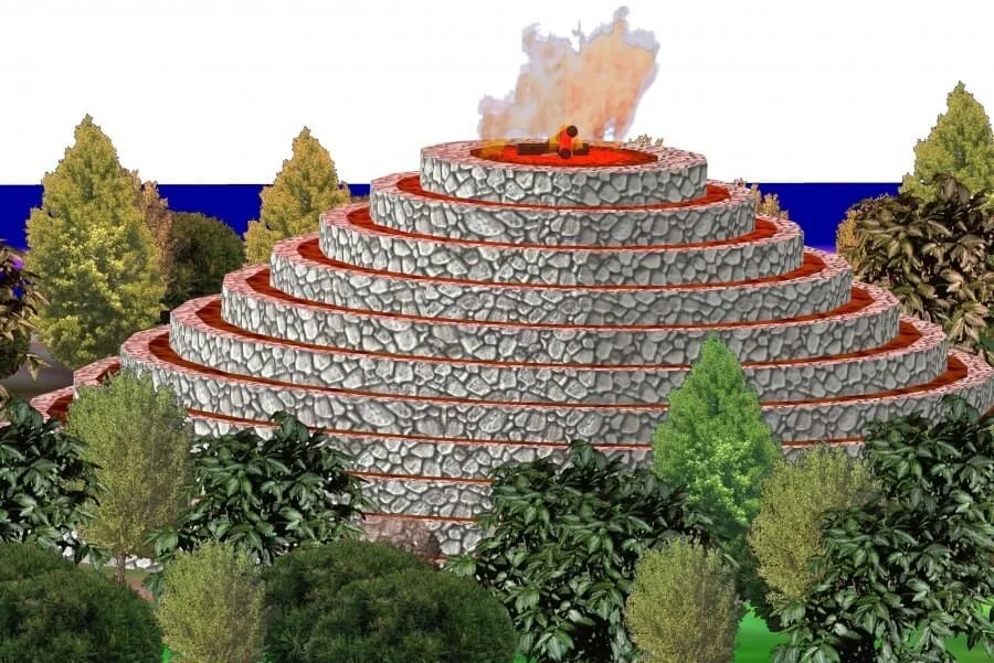
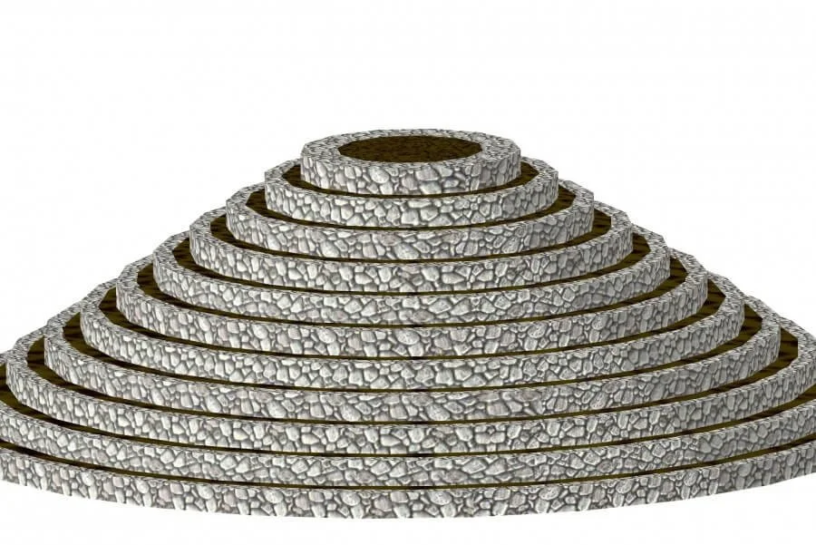
Panagiotakis’s publications at international conferences and years of field research reveal that Minoan Sorous are large truncated-cone structures (made of walls and earth)—in essence, platforms upon which signal fires were kindled. They represent a colossal engineering achievement of the Minoan era—comparable in conception and execution to the Minoan palaces. Their function was both communicative and defensive: enabling Minoan authorities to monitor coasts, roads, and all regions of strategic importance and to relay signals across these points rapidly.

A Network Spanning All of Crete

A large number of beacons likely covered the entirety of Crete, allowing messages to traverse the island—and reach nearby Aegean islands—very quickly. Thus, these beacons ensured communication with surrounding regions and islands, the secure transport of goods, and likely safe navigation.

View fullsize imgi_14_soroi2007-version2.jpg
View fullsize imgi_16_stigmiotypo-o8onhs-2025-07-05-142012.jpg
View fullsize imgi_17_stigmiotypo-o8onhs-2025-07-05-141925.jpg
View fullsize imgi_21_stigmiotypo-o8onhs-2025-07-05-142000.jpg

Panagiotakis’s Lifelong Dedication

Archaeologist Nikos Panagiotakis devoted much of his life to his native region—without institutional funding, he systematically “combbed” the Pedias area of Central Crete, the hinterland of the Minoan palatial cities of Knossos and Malia. Between 1982–1989 and 2001–2009, in an 800 km² area, he identified around 2,500 archaeological sites dating from the Neolithic to Ottoman periods.

Among these were earth-covered hill-like features still called “Sorous.” His surface survey revealed the secret previously hidden for 4,000 years: these 200 or so Sorous are visible across the Pedias plains, detectable by ash and heat-altered soil layers—evidence that fires were regularly lit atop them.

The Nature and Function of the Sorous

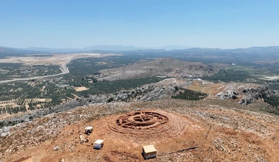
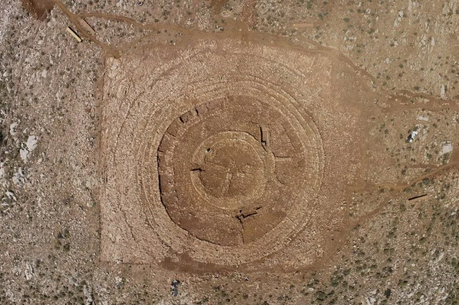
The Sorous—named by later locals and still present—are truncated-cone structures built from concentric or semicircular stone walls filled with soil, located on hills or ridges. They range from 5 to 60 meters in diameter and 2 to 8 meters in height. At their tops, red clay soil was placed and fired by rainfall and beacon fires, producing scattered shards of baked clay originating from the uppermost level of the beacon structure. Thus, all Sorous contain abundant pieces of baked clay on their surfaces.

Panagiotakis explains that he gradually recognized the function of these Sorous: as massive visibility constructions on hilltops and ridge-lines marking critical junctions—and smaller structures that demarcated and monitored ancient roads. All Sorous, regardless of size, share the same features: truncated-cone shape, concentric and transverse walls, indicating shared design principles.

These structures enabled fast, safe, and efficient message transmission across both short and long distances—virtually eliminating geographic barriers. They also served defensive and fortification functions, protecting travelers, trade, and transport. The Sorous had direct line-of-sight from the north to the south coast of Crete to relay messages swiftly over great distances.

Satellite Imaging and Hierarchical Network Structure

Collaboration with the Institute for Mediterranean Studies under Professor Apostolos Sarris used satellite imagery to map the complete communication system, the control zones of each beacon, and their interconnections. Analyses demonstrated a dense communication network between Sorous and Minoan settlements, suggesting a hierarchical structure based on their use, location, and control range. Some were larger, others smaller. The largest and best-preserved— the Pantelis Soros—spans over 2.5 acres.

The most important Sorous were positioned along the northern coastline and to the east and west of Panagiotakis’s research area—where immediate warning was vital in case of invasion.

Operational Details: Guards, Infrastructure, and Defense

Panagiotakis describes the system’s operation: palace officials selected hills or elevated sites to light fires. Guards stationed in shifts awaited signals from visually connected elevations. “Installation” meant actual buildings where guards lived, stored food and fuel, and could defend themselves if attacked. The presence of functional pottery and obsidian blades in many Sorous indicates permanent garrisoning. These were likely staffed by military personnel or local reinforcements, operating around the clock. A defensive role is evident in the narrow single entrance found in excavations by the Heraklion Antiquities Authority.

Sorous date from the Early to Late Palace periods (c. 1900–1700 BCE). The Pantelis Soros alone holds approximately 5,500 m³ of earth and stone, marking its construction as a monumental achievement. Most building material came from the local area in abundance.

Why the Conical Shape and Elevated Sites?

Panagiotakis explains: today the hills of the Pedias region are devoid of dense vegetation. He believes the soros’s height was dictated by surrounding tree canopy heights. The structure needed to elevate beacon flames above vegetation, implied by the presence of baked clay. The truncated cone shape also provided structural stability and minimized fire spread—its broad base functioning as a firebreak, with only a small top section exposed for fire.

The Papoura Soros: A Minoan “Radar”?

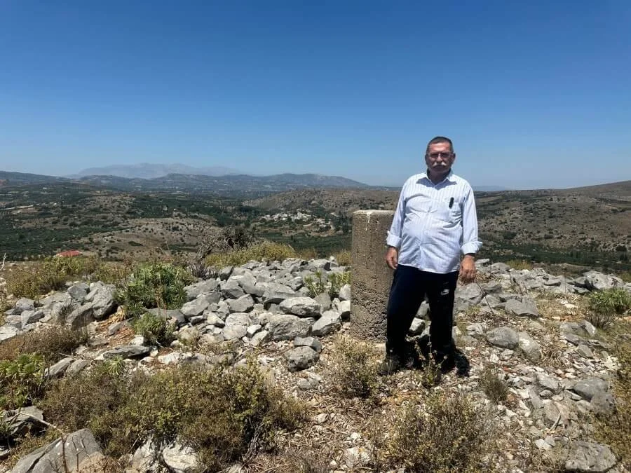
When asked specifically about the Papoura Soros at Kastelli—the site of the exciting new find—Panagiotakis says: “Excavation by the Heraklion Antiquities Authority revealed a more impressive monument than I had imagined. Its meticulously engineered structure points to palatial authority aimed at controlling territories and roads between the hinterland and palace centers to secure movement of people and goods. Just as Mesopotamian trade stations lined routes, some Sorous may have served as traveler waystations”.

He stresses that monuments should not be studied in isolation but in relation to others of similar type. The Papoura Soros closely resembles the larger Pantelis Soros, both built with concentric walls forming truncated cones. In Papoura, one can now see cross-walls forming a cruciform structure supporting the roof. Above that lay a clay cap—despite damage from German WWII pillboxes, fragments of fired clay remain on the surface. Other Sorous also hosted wartime fortifications.

That modern radar for Kastelli Airport was placed on Papoura underscores the monument’s strategic importance as part of an ancient system of communication and defense—much like modern radar systems.

Continuity and Modern Use: From Antiquity to the Information Age

Remarkably, these elevated sites were reused through successive eras—from Homeric to classical Greece through the Ottoman period, even into modern times. Folk tradition recalls that when a Cretan killed a Turk, he fled to a nearby island (often Kasos). Islanders received messages via beacon fires starting from the Toplou Monastery bell tower in Lasithi—and then dispatched boats to retrieve the fugitive.

In our time, the Papoura Soros was selected for radar placement. During the Cold War, large telecom radar installations at the Ederi Soros destroyed parts of the mound. Today, many Sorous host telecommunications antennas for major mobile carriers—continuing their legacy as high-visibility signal points.

Discovering the Minoan beacon-Sorous system in the 21st century—an era heralded as the Information Age—is particularly meaningful.

Open Questions and the Future of Research

Key questions remain: Were these systems exclusive to Minoans on Crete, or did similar constructions exist throughout the Aegean world? The Minoans had relations with northern neighbors and Aegean islanders. Geophysical analysis on a mound near Volos, mainland Greece, found signs of similar ground burning. Panagiotakis believes research should expand from Crete to the wider Greek area.

What remains to be officially confirmed—if the archaeological services of Crete and the Greek Ministry of Culture choose to seriously engage with these findings—is that the brilliant monument at Papoura Kastelli is just one of many Sorous in Minoan Crete within a complex telecommunication network. If validated, Papoura Soros could trigger the protection, promotion, and display of all Minoan beacon-Sorous across Crete as integral components of a monumental Minoan infrastructure. They should be safeguarded under archaeological law as discoveries of major significance.

In Aegean Prehistory Tags D

Helike: The Ancient Greek City Swallowed by the Sea but Never Lost

July 26, 2025

One night in 373 BCE, the earth beneath the ancient Greek city of Helike shook violently and split apart. As homes and temples collapsed, a giant wave—a tsunami from the Corinthian Gulf—engulfed everything. Helike, the capital of Achaea, vanished from the map. No human remains were ever recovered by archaeologists.

For centuries, the city’s fate was cloaked in legend. It inspired Plato’s story of Atlantis, haunted Roman travelogues, and puzzled scholars. However, a new study published in the journal Land by a team of Greek and British researchers breathes new life into Helike’s story. As the study reveals, the city was destroyed multiple times—and each time, it was rebuilt nearby.

“The ancient inhabitants of the region consistently chose to rebuild in the same geographical zone,” note the authors, led by Dora Katsonopoulou, director of the Helike Project. “By adapting their way of life to the landscape and natural hazards, they consistently overcame the challenges.”

Their work, spanning over 30 years, is one of the most detailed case studies of human resilience in the face of disaster.

A Landscape in Constant Motion

Helike wasn’t destroyed just once. It went through successive cycles of life and destruction.

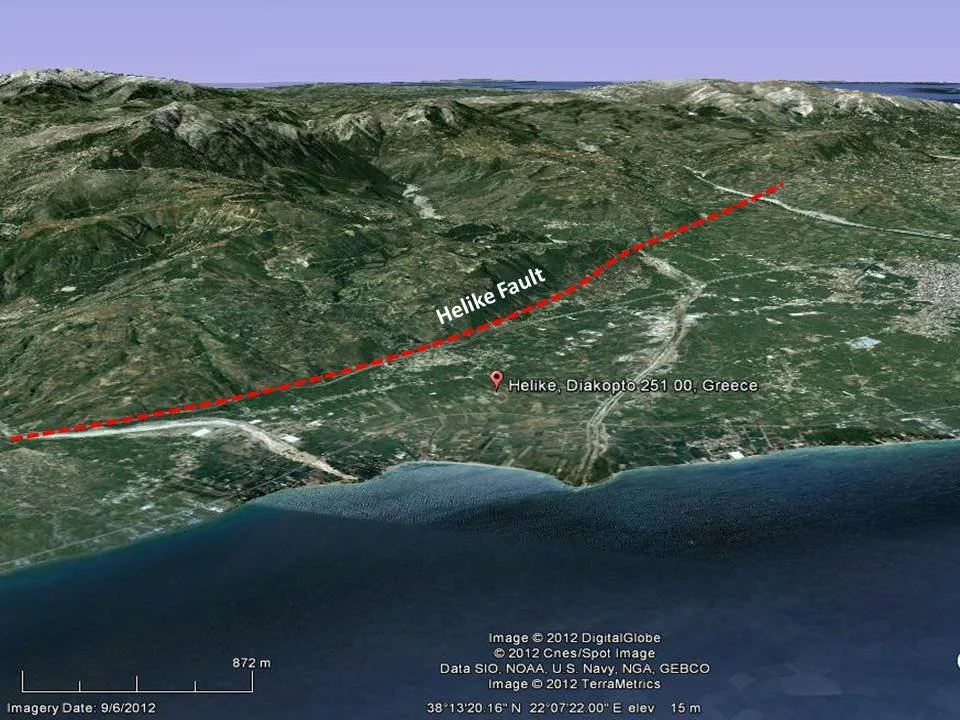
Founded during the Bronze Age on a fertile coastal plain between two rivers, the city had a strategic location for trade, but also a dangerous proximity to Europe’s most seismically active gulf. Roughly every 300 years, strong earthquakes and tsunamis struck the area.

Yet its people never truly abandoned the site. After each disaster, they relocated a short distance away and rebuilt. Following the catastrophe of 373 BCE, the survivors moved westward and established a new city. Archaeologists have discovered textile workshops at the site, suggesting rapid economic recovery.

Using sediment cores, stratigraphic analysis, and digital terrain modeling, researchers were able to map out these relocations. A major earthquake in 2100 BCE triggered a flood that buried a Bronze Age settlement. By Roman times, the same land had risen enough to host a major road.

The movement wasn’t random. Inhabitants remained rooted to place—but adapted to its changing form.

The Archaeological Footprint of Earthquakes

Excavations across the Helike plain have uncovered alternating layers of destruction and reconstruction. The soil bears the marks of seismic trauma: walls tilted at strange angles, pottery smashed in place, and—in one of the most haunting finds—the skeleton of a man buried alive under collapsed debris.

One trench revealed an until-now-unknown earthquake around 700 BCE, with a fault line cutting straight through building walls. Builders had tried to guard against future quakes by constructing on bedrock and using high foundations—suggesting early seismic awareness.

After the 373 BCE disaster, architecture changed: structures began to use polygonal masonry, more resistant to tremors. Following another major quake in the 1st century BCE, the city was relocated again, this time to the east.

During the Roman era, a road passed through the ruins, winding between half-collapsed workshops. When the traveler Pausanias visited in the 2nd century CE, this road was still visible.

Myth, Memory, and the Sea God

Ancient peoples tried to explain such destruction in their own terms. Aristotle attributed earthquakes to subterranean winds. Others saw the wrath of Poseidon, god of the sea and earthquakes, whose temple in Helike drew pilgrims from across Greece. For centuries, sailors claimed to see the bronze statue of Poseidon submerged, still holding his trident.

The historian Diodorus Siculus wrote: “A wave of enormous size, greater than any before, swallowed everything—people and homeland.” Other accounts mention that only the tops of Poseidon’s sacred trees remained visible above the water.

Yet modern excavations do not confirm the presence of a permanently submerged city. Instead, they point to a constantly shifting landscape: earthquakes that tilt the land, rivers that change course, lakes that appear and vanish. The “tsunami” of 373 BCE may also have involved inland flooding caused by landslide-created dams—an entirely plausible scenario for the area.

Lessons from the Past

What makes this study stand out is not just its geological accuracy—but its human story. The people of Helike did not despair in the face of destruction. They responded intelligently, inventively, and with adaptability.

Their city wasn’t bound to any single structure or layout. It was a persistent idea, tied to the land—but not fixed in place. This flexibility, the researchers argue, is the true essence of resilience. It’s a lesson worth studying by those designing cities today in areas vulnerable to earthquakes or rising seas.

As the researchers write: “The society of Helike demonstrated sustained resilience to disaster. One could say that, having faced severe environmental risks for generations, it learned from experience and developed effective solutions.”

Helike is not merely a buried ruin. It is a parable—of loss, endurance, and the long memory of the earth.

Source: Land journal / Helike Project

Tags D

Before Aesop: The First Cunning Fox in Human History Revealed Recently in Sumerian Myth

July 22, 2025

Enlil, Ishkur, and the Clever Fox: A 4,400-Year-Old Sumerian Myth of Captivity and Rain Restored

In a recent study published in the academic journal Iraq, Assyriologist Dr. Jana Matuszak has produced the first full critical edition and translation of a long-overlooked Sumerian tablet, shedding light on a mythic narrative dating back approximately 4,400 years. The tablet in question, designated Ni 12501, originates from the ancient city of Nippur and belongs to the Early Dynastic IIIb period (ca. 2540–2350 BCE), a formative era in Mesopotamian civilization.

Although the tablet was excavated as early as the 19th century, it was never fully published or analyzed. Part of the reason for this neglect may stem from its fragmentary condition—less than one-third of the original text survives—which has made interpretation difficult. Another obstacle was bibliographic confusion: when the tablet’s text was partly quoted by renowned Sumerologist Samuel Noah Kramer on the dust jacket of a 1956 book, he failed to include its museum registration number, identifying it only in a subsequent publication five years later.

Despite its damaged state, Ni 12501 offers a rare glimpse into the Sumerian mythological imagination—particularly through its narrative, which features prominent deities and unique motifs not seen elsewhere in the surviving corpus.

Historical and Religious Context

The tablet was inscribed around 2400 BCE, during a time when Sumer was composed of independent city-states, each governed by its own institutions and centered around a tutelary deity. As Dr. Matuszak explains, "Each city-state had one patron deity (who in turn had an entire family and staff)." In Nippur, this was Enlil, the head of the Sumerian pantheon, whose sanctuary dominated the religious life of the city.

Although politically autonomous, the city-states shared a common language, administrative traditions, and religious structure. Variations existed—such as different dialects of Sumerian and local panthea—but core deities like Enlil and Ishkur were widely known. Ni 12501, while seemingly part of a Nippurite tradition, fits into this broader Mesopotamian religious framework.

The Narrative: Ishkur in the Netherworld

The fragment centers on a myth in which the storm god Ishkur—often associated with seasonal rains and agriculture—is trapped in the netherworld (kur). His father, Enlil, convenes a divine assembly, seeking a volunteer to descend into the underworld and retrieve his son. Of all the gods, only Fox steps forward to undertake the perilous mission.

Fox, in a display of cunning, gains access to the netherworld by accepting—but not consuming—food and drink offered to him. Instead, he stores them in a receptacle, thus bypassing the binding rules of the underworld. The story abruptly ends here due to damage on the tablet, and it remains uncertain whether Fox ultimately succeeds in rescuing Ishkur.

Nonetheless, even in its fragmentary state, the myth resonates with themes common in later Mesopotamian and broader Near Eastern traditions: the daring descent into the netherworld, the clever trickster, and the restoration of order by an unlikely savior.

Themes and Symbolism

The narrative opens with a vivid tableau of agricultural abundance—"glittering waters," fish-filled rivers, and multicolored cows belonging to Ishkur—before shifting into desolation. Ishkur’s captivity seems to coincide with a cessation of natural fertility, represented metaphorically through the abduction of children by the kur, possibly alluding to drought and famine.

This transition from plenitude to scarcity, followed by the anticipated return of the storm god, may encode a cyclical agricultural myth, tied to the seasonal rhythm of rains and crop renewal. The motif parallels other ancient traditions involving dying and returning gods.

The character of the Fox—depicted here as both daring and shrewd—marks the earliest known instance of this animal as a trickster figure in Mesopotamian myth. The fox’s cleverness and willingness to do what other deities cannot recalls broader literary tropes of lowly or marginal figures achieving divine goals—a pattern seen in myths worldwide.

Significance and Legacy

As Dr. Matuszak notes, "The Nippur fragment Ni 12501... is the only narrative in which Ishkur plays a leading role." Although he appears elsewhere in hymns and god lists, he rarely occupies the central position reserved here. This makes the tablet all the more valuable, offering a rare window into both the evolving Sumerian pantheon and the myth-making of the time.

Moreover, the story reflects cultural realities: in southern Mesopotamia, rainfall was insufficient for agriculture, and extensive irrigation systems were essential. This likely reduced Ishkur’s relative importance compared to storm gods in rain-fed regions, such as the Semitic god Hadad. Yet in Ni 12501, Ishkur takes center stage, perhaps revealing a regional or localized devotional tradition in Nippur.

Toward a Fuller Picture of Sumerian Myth

Although much of the tablet is missing and its original context remains elusive, Ni 12501 is a valuable piece in the larger puzzle of Mesopotamian literature. Its motifs—captivity in the netherworld, divine rescue, agricultural abundance, and trickster heroism—resonate across the centuries in both Sumerian and later Akkadian mythologies.

Dr. Matuszak’s careful philological work underscores the continuing importance of revisiting understudied or neglected artifacts, especially those still housed in museum collections without full publication. Her edition of Ni 12501 not only revives a fragment of mythic storytelling but also reaffirms how even broken tablets can enrich our understanding of ancient worldviews.

Citation:
Jana Matuszak, “A Myth from Nippur about Ishkur’s Captivity in the Netherworld (Ni 12501),” Iraq 86 (2024): 1–26.

In Mesopotamia Tags D, Studies

The Priene Inscription: Alexander the Great’s Temple Dedication and Panhellenic Diplomacy

May 21, 2025

The Priene Inscription stands as one of the most revealing and evocative artifacts from the early years of Alexander the Great’s conquest of the East. Carved on marble and discovered in the Ionian city of Priene (modern-day western Turkey), the brief yet powerful dedication reads: “King Alexander dedicated the temple to Athena Polias.” This deceptively simple line encapsulates a strategic act of religious patronage, a signal of cultural legitimacy, and a statement of Panhellenic diplomacy. More than a mere building inscription, it reflects Alexander’s broader efforts to present himself not simply as a conqueror, but as the lawful leader and unifier of the Greek world.

Historical Context: After the Granicus

Dated to around 334–330 BC, the inscription comes from the early phase of Alexander’s campaign against the Persian Empire. Shortly after crossing the Hellespont into Asia Minor, Alexander won a decisive victory at the Battle of the Granicus River, defeating a coalition of Persian satraps. In doing so, he liberated several Greek cities in Asia that had been under Persian dominion for over a century.

Among these cities was Priene, a Hellenized polis in Ionia with strong civic traditions and deep cultural roots. Like other Ionian cities, it had maintained Greek identity despite Persian control, often preserving local autonomy under the oversight of satraps. As Alexander swept through the region, he sought not only to assert military dominance but also to legitimize his authority through acts of restoration and cultural alignment. His decision to dedicate a major temple in Priene to Athena Polias – the city’s protector goddess – should be read within this context of symbolic liberation and Panhellenic outreach.

The Temple of Athena Polias and Alexander’s Role

The temple itself was an ambitious project that had begun prior to Alexander’s arrival but was unfinished at the time. Athena Polias (“Athena of the City”) was more than a patron deity—she was a personification of civic identity, order, and defense. By completing and dedicating her temple, Alexander positioned himself as a restorer of Greek civic religion and as a benefactor deeply respectful of traditional values.

Financing the construction of the temple was a concrete demonstration of royal generosity and religious piety. It followed a long-standing Greek tradition in which rulers enhanced their prestige and cemented alliances by sponsoring sacred buildings. In this case, however, the patron was not a local tyrant or oligarch, but a pan-Hellenic figure who claimed to act on behalf of all Greeks. The temple thus became an instrument of imperial diplomacy: a gift to a liberated Greek city, affirming Alexander’s role as protector and champion of Hellenic religion.

The simplicity of the inscription—“King Alexander dedicated the temple to Athena Polias”—is also notable. It deliberately avoids any imperial Persian title and uses the Greek royal titulature, signaling his status as a Hellenic king rather than a foreign autocrat. This decision contrasts with later titles he adopted in Egypt (e.g., Pharaoh) or in Persia (e.g., King of Kings), highlighting how his policies in Greek cities were tailored to their cultural and political expectations.

Panhellenic Messaging and the Politics of Religion

Alexander’s temple dedication at Priene was part of a wider campaign of cultural diplomacy. Throughout his journey across Asia Minor, he emphasized liberation rather than conquest. He frequently proclaimed the freedom of the Greek cities—a politically resonant phrase evoking the autonomy and self-governance that many poleis had lost under Persian rule. These proclamations were reinforced by visible, religiously charged acts like temple construction and sacred dedications.

Such gestures appealed not only to civic pride but also to shared Greek values and memory. Athena was a Panhellenic deity par excellence: venerated from Athens to Ionia and closely associated with wisdom, strategy, and urban life. By invoking her patronage, Alexander reinforced his connection to the Panhellenic tradition of heroic warfare and religious duty. This act echoed previous dedications, such as the 300 Persian armors he sent to the Acropolis of Athens after Granicus, inscribed in the name of “Alexander and the Greeks (except the Lacedaemonians).” In each case, his message was the same: he was leading a war of revenge and liberation on behalf of all Greeks.
Furthermore, dedicating temples also served a practical political purpose. It helped solidify loyalty among the newly liberated cities, ensured the cooperation of local elites, and mitigated resistance. Religious benefaction made Alexander appear not as an occupier, but as a restorer of divine order and protector of the sacred.

The Priene Inscription and the Panhellenic Ideal

The importance of the Priene Inscription lies not only in its immediate context but in its broader ideological implications. It represents a fusion of conquest and consensus, where religious patronage becomes a tool for legitimizing imperial authority within a Panhellenic framework. Unlike the brutal subjugations that often followed conquest in antiquity, Alexander’s approach (at least in the Greek cities of Asia Minor) emphasized continuity, reverence, and shared cultural values.

This policy was deeply informed by his father Philip II’s legacy and the rhetoric of thinkers like Isocrates, who had long called for a united Greek campaign against Persia under a single hegemon. The Priene temple dedication offered tangible proof that Alexander had taken up this mantle—not merely militarily, but also spiritually and civically. It also reveals how he skillfully balanced local identities with imperial ambition: in Priene, he was not a foreign despot but a Greek king honoring the polis’s guardian goddess.

Moreover, the inscription’s very preservation provides insight into how Alexander’s legacy was curated and remembered. While his empire would fragment after his death, the memory of acts like this – recorded in stone and tied to civic institutions – helped sustain his image as a unifier, not merely a conqueror.

Conclusion

The Priene Inscription may consist of only a few words, but it conveys a wealth of historical meaning. It testifies to Alexander’s awareness of the importance of religious tradition, his deliberate cultivation of Greek identity, and his strategic use of cultural symbols to reinforce political authority. In dedicating the temple to Athena Polias, Alexander was not only finishing a building; he was also erecting a monument to Panhellenic diplomacy, civic renewal, and ideological legitimacy.

As such, the inscription remains a vital key to understanding how Alexander crafted his public image and how he navigated the delicate balance between Macedonian monarchy and Hellenic political traditions. It captures, in marble and in spirit, the subtle art of empire-building in the ancient world.

In Greece's Historical Period Tags D, The Archaeologist Editorial Group

The Historical Method in the Analysis of Christianity and Its Limits in Relation to Theological Truth

March 28, 2025

In contemporary historical-critical thought, the historical method is one of the primary approaches to understanding cultural phenomena such as art, institutions, and most notably, religion. The use of this method has led to numerous analyses regarding the spread of Christianity, the role of the Roman Empire, the so-called "imposition" of the faith, and even the deconstruction of the divine nature of religious experience. The young Hegel, already in the late 18th century, analyzed how Christianity evolved from a local movement into a global force through the historical channels provided by the Empire. But is this historical perspective sufficient to exhaust the essence of the Christian faith?

This article explores the limitations of the historical method when interpreting Christianity while placing theological and dogmatic insight as essential to fully understanding the phenomenon. While historical analysis provides tools to grasp the external development of Christianity, it cannot access the inner truth and spiritual experience of faith.

The Historical Context: Christianity as a Cultural Phenomenon

The historical method examines how cultural phenomena emerge, develop, and are shaped by social, political, and economic structures. When applied to Christianity, it often focuses on how the new faith adapted to the Roman world, how it benefited from the Pax Romana, and how its establishment as the official religion under Constantine altered its spiritual course.

Indeed, we cannot ignore that Christianity moved through history aided by key circumstances. However, if this interpretation remains solely at that level, it leads to a reductionist, perhaps even demystifying, view of the phenomenon. If Christianity were merely a historical product, how do we explain the enduring power of faith across centuries, the resistance of the early martyrs, and the sacrificial devotion to a message that often cost believers their lives?

Theological Depth and the Limits of Historical Analysis

Theology, and dogmatics in particular, introduces a different dimension. It does not treat faith as an external phenomenon but as an inner revelation and experience. It sees Christianity not as the result of circumstances but as an expression of Divine Providence. The doctrines of the Incarnation, the crucifixion, and the Resurrection of Christ cannot be analyzed with historical tools. These are not historical facts in the sociological sense, but revelatory truths that transcend historical time.

This dimension gives Christianity its uniqueness. It is not confined to a moral philosophy or a religious ethical community but proclaims a theanthropic reality that transforms the world. Even the structure of the Church and the teachings of the Fathers cannot be fully explained historically, for they stem from the experience of divine grace, not from a purely social construct.

Imposition or Acceptance?

A common argument among those who interpret Christianity through a historical lens is the supposed "imposition" of the faith. However, this overlooks the fact that Christianity was persecuted for three centuries before being recognized. If it were merely a tool of power, it would not have such a martyric beginning. Faith was not "imposed" — ” "conquered" consciences, even amidst persecution, through love, hope, and a message of salvation. Early believers were not persuaded by laws but by persons and truths that deeply changed them.

Epilogue

The historical method is valuable for understanding the external aspects of Christianity's journey. It helps us see how divine revelation found passageways through history. However, it cannot exhaust the phenomenon of faith. Theology — especially dogmatics — reveals that faith is not merely the result of conditions but the fruit of revelatory experience, of relationship, and of divine illumination. If Christianity were merely a historical phenomenon, it would not have lasted for centuries, nor would it have inspired the human mind and heart so profoundly.

Therefore, those who use the historical method to dismiss or relativize the Christian truth forget that behind history is not only society but also God, who acts within history — sometimes silently, but always with the purpose of salvation.

  • "The Historical Method of Reading Early Christian Theology: Essays in Honor of Michel René Barnes"

  • Overview: This collection examines how historical methods can be applied to early Christian theological texts, emphasizing the importance of context in theological interpretation.​

  • Access: JSTOR

  • "Historical Methodology and New Testament Study"

    • Author: The Gospel Coalition​

    • Overview: This article discusses the application of historical methodologies in New Testament studies, addressing the challenges and benefits of integrating historical analysis with theological inquiry.​

    • Access: The Gospel Coalition

  • "The Quest for the Historical Jesus as an Experiment in Theological Method"

    • Author: Bernard Lonergan​

    • Overview: This paper explores the search for the historical Jesus as a theological endeavor, discussing how historical research can inform and shape theological understanding.​

    • Access: Sage Journals

  • "Historical Theology: Content, Methodology and Relevance"

    • Author: Louis C. Jonker​

    • Overview: This article reflects on historical theology as a discipline, proposing its application to various areas of research, including church history and missions.​

    • Access: SciELO South Africa

  • "Historical Theology"

    • Author: The Gospel Coalition​

    • Overview: This essay traces the development of Christian theology through various historical periods, highlighting the importance of understanding theological evolution in context.​

    • Access: The Gospel Coalition

Tags Religion, The Archaeologist Editorial Group, D

All Scholars Agree: Jesus Christ Is Not a Copy of Pagan Deities

March 28, 2025

In the age of informational overload, many theories and narratives survive not because they are true, but because they are presented persuasively—cloaked in skepticism, half-truths, and pseudo-academic terminology. One such example is the infamous documentary Zeitgeist, which attempts to portray Jesus Christ as a mere imitation of ancient pagan deities such as Horus, Mithras, Dionysus, and Krishna. Although this narrative appeals to some for its anti-establishment stance, historical and theological research clearly demonstrates that these comparisons are superficial, often flawed, and at times outright misleading. This article seeks to dismantle the shallowness of such theories by examining each case separately and demonstrating the uniqueness of Jesus Christ through reliable sources and scholarly literature.

The Case of Horus

The Egyptian god Horus, son of Isis and Osiris, is often cited by proponents of the mimicry theory as a deity who was born of a virgin, walked on water, had twelve disciples, and resurrected after three days. However, none of these claims are supported by authentic Egyptian sources.

Isis conceived Horus after collecting the dismembered body parts of Osiris, her slain husband. This act does not equate to virgin birth. Horus is not recorded to have walked on water, nor did he have twelve disciples. Instead, he is portrayed as a warrior god who avenged his father’s death. There is no account of crucifixion, resurrection, or sacrificial death for the redemption of humanity. His stories are theological and cosmogonical myths devoid of historical framework.

The Case of Mithras

Mithras, originally a Persian deity later venerated in the Roman Empire, is another figure often claimed to prefigure Jesus. Critics argue that Mithras was born of a virgin on December 25, had twelve disciples, resurrected from the dead, and offered salvation. However, historical and comparative religious studies show these claims to be unfounded.

In reality, Mithras is depicted as emerging fully grown from a rock (petrogenesis), not born of a virgin. There is no conclusive evidence of Mithras having twelve disciples. The association with December 25 is anachronistic and arises from later Christian liturgical developments, not from Mithraic worship. Furthermore, there are no surviving Mithraic texts that document a resurrection or salvific function comparable to Christ.

The Case of Dionysus

Dionysus, the Greek god of wine and ecstasy, is also presented as a precursor to Christ due to superficial similarities such as turning water into wine, dying and rising again, and being referred to as a "divine child." However, Dionysian mythology is steeped in initiatory and naturalistic symbolism, lacking any salvific or historical depth.

In some myths, Dionysus does die and return, but the motif reflects the cycles of nature rather than a victory over death or a promise of eternal life. The notion of water-to-wine is metaphorical, not a recorded miracle. No theological system attributes atonement for sin or redemption to Dionysus. There is no primary source referring to him as "Savior of the world" or a divine redeemer.

The Case of Krishna

Krishna, a central figure in Hinduism and considered an avatar of Vishnu, is often said to be similar to Jesus due to his divine birth, miracles, and spiritual teachings. Yet these similarities are more coincidental than substantive.

Krishna’s mother, Devaki, was not a virgin, and his birth took place in a polytheistic theological context entirely alien to Jewish monotheism. His miracles involve military feats and playful acts, rather than healings or spiritual instruction centered on forgiveness and divine love. Moreover, Krishna's narrative is mythic in character, whereas the life of Jesus is embedded in historical claims, eyewitness testimony, and legal-political settings under the Roman Empire.

The Fallacy of Half-Truths and Surface-Level Comparisons

Zeitgeist and similar productions employ a common technique: they extract decontextualized fragments of myths, distort their meanings, and present them as evidence of plagiarism. However, serious historical research requires the use of primary sources, critical comparison of theological narratives, and careful evaluation of cultural frameworks.

This is not academic inquiry; it is syncretistic propaganda driven by the logic of "if it looks similar, it must be the same." If we applied this reasoning consistently, then modern fictional characters like Superman or Gandalf could be accused of copying Jesus because they die and return. But resemblance alone does not imply derivation.

The Uniqueness of Jesus Christ

Unlike the mythological figures discussed above, Jesus is a historical person whose life, teachings, crucifixion, and resurrection are attested by eyewitnesses and recorded in Jewish, Roman, and early Christian sources. His mission was not to mirror seasonal change or initiate followers into secret cults, but to offer salvation through love, forgiveness, and grace.

The incarnation of God in human form, His voluntary death by crucifixion, and His resurrection—not as a seasonal rebirth but as a decisive victory over sin and death—are without parallel in any ancient mythology. Christ did not come to mystify but to redeem. He did not demand sacrifice; He became the sacrifice.

By Wesley Huff

Conclusion

The comparisons between Jesus and ancient deities do not withstand serious scholarly scrutiny. The alleged similarities are illusory, and the differences are profound. Christianity did not emerge from pagan mysticism but from divine intervention in human history.

Rather than recycling ahistorical narratives that thrive on intellectual laziness and internet sensationalism, we must engage the topic with respect for historical complexity and theological integrity. Most importantly, we must recognize the singularity of Jesus Christ, who changed the course of human history—not with myths, but with the truth of the Cross and the empty tomb.


Bibliography and Relevant Sources:

  • Dr. Edwin Yamauchi – "Christianity and the Mystery Religions: Did the New Testament Borrow from Pagan Thought?" (Published in Bibliotheca Sacra, Vol. 121, 1964)

  • Dr. Ronald Nash – The Gospel and the Greeks: Did the New Testament Borrow from Pagan Thought?, Zondervan, 1992

  • Dr. Bart Ehrman – Did Jesus Exist? The Historical Argument for Jesus of Nazareth, HarperOne, 2012

  • J.P. Holding – "Shattering the Zeitgeist Movie" series on Tektonics.org

  • Lee Strobel – The Case for the Real Jesus, Zondervan, 2007 (esp. chapter on pagan copycat claims)

  • Dr. Gary Habermas and Dr. Michael Licona – The Case for the Resurrection of Jesus, Kregel Publications, 2004

  • Dr. Peter J. Williams – "Can We Trust the Gospels?", Crossway, 2018

  • Jonathan Morrow – "22 Reasons All Scholars Agree Jesus Is Not a Copy of Pagan Gods" – ReasonsForJesus.com

  • Greg Koukl (Stand to Reason) – "Jesus, Recycled Redeemer?" – STR.org

  • GotQuestions.org – "Is Jesus a Myth?" – gotquestions.org/Jesus-myth

Tags Religion, The Archaeologist Editorial Group, D

Philosophy and Theology in Europe: From Synthesis to Separation

March 24, 2025

The relationship between philosophy and theology has been one of the most fruitful and complex in the history of European thought. From antiquity to the modern era, these two intellectual traditions have been in constant dialogue, sometimes reinforcing each other and sometimes clashing. The role that philosophy has played in shaping theological thought is undeniable, as is the influence of theology on the development of philosophy. Particularly in the Middle Ages, philosophy served as a means to understand and interpret religious faith, while from the Enlightenment onward, its gradual emancipation marked a profound transformation in Western intellectual tradition.

Philosophy as the Handmaid of Theology: A Tool for Theological Understanding

During the Middle Ages, philosophy was seen as an essential tool for theology. The concept of Ancilla Theologiae (“handmaid of theology”) highlighted the way in which philosophy was employed to reinforce theological principles, providing logical structure and systematic argumentation for religious doctrines.

Thomas Aquinas (1225-1274) was one of the most influential thinkers of this era, merging Aristotelian philosophy with Christian doctrine. His work, Summa Theologica, sought to reconcile faith and reason by arguing that divine truths can be partially comprehended through human reason, although revelation remains the ultimate authority. This synthesis formed the foundation of Thomism, which dominated medieval theology.

Other medieval scholars, such as Anselm of Canterbury, proposed philosophical arguments for God's existence, while figures like Boethius and John Duns Scotus contributed significantly to philosophical theology by refining theological and metaphysical concepts.

Medieval University Structures and the Dominance of Theology

The intimate relationship between philosophy and theology was institutionalized through the medieval university system. Leading institutions, including the Sorbonne, Oxford, and the University of Padua, prioritized theology as the highest academic discipline.

The education system was based on the Septem Artes Liberales, which included foundational disciplines meant to prepare students for theological studies. Among these, philosophy—especially logic—was a key tool for theologians, enabling them to construct rational defenses of religious dogma.

Furthermore, Neoplatonism, heavily influenced by Plato, played a crucial role in early Christian thought. Saint Augustine, one of the most prominent Church Fathers, adopted Neoplatonic ideas, emphasizing that the material world is secondary to the spiritual realm and that true knowledge is obtained through divine communion.

The Separation of Theology and Philosophy in the Enlightenment

The harmonious relationship between philosophy and theology began to dissolve in the 17th and 18th centuries with the rise of Enlightenment rationalism. Philosophers increasingly sought to base knowledge on empirical evidence and reason, distancing themselves from theological constraints.

Descartes’ skepticism, Spinoza’s pantheism, and Locke’s empiricism all contributed to this philosophical emancipation. Additionally, the Scientific Revolution, led by Galileo and Newton, established a mechanistic and empirical approach to understanding the natural world, further diminishing theology’s traditional authority.

Kant’s Critique of Pure Reason delivered a final blow to traditional metaphysics, arguing that theological claims could not be verified through pure reason.

The Contemporary Relationship Between Philosophy and Theology

Although philosophy and theology are now distinct academic fields, their dialogue persists in disciplines such as the philosophy of religion, ethics, and metaphysics. Theology remains deeply rooted in faith and revelation, while philosophy continues to explore questions about existence, morality, and the limits of human knowledge.

Despite their divergence, history demonstrates that philosophy and theology have never ceased influencing one another. Their interaction continues as they both seek to provide answers to the great existential and ethical dilemmas of humanity.

Tags The Archaeologist Editorial Group, D, Ancient Life Lessons

The Optical Illusions that Make Parthenon Straight to Human Eye

November 12, 2024

The Parthenon, an enduring symbol of ancient Greek architecture, captivates observers with its apparent perfection and harmonious proportions. This visual mastery results from deliberate architectural refinements—subtle deviations from geometric norms—implemented by its creators to counteract optical distortions and enhance aesthetic appeal.

Curved Stylobate

A notable refinement is the curvature of the stylobate, the temple's base platform. Instead of being flat, the stylobate arches upward slightly, with a rise of approximately 2.6 inches at the center of the end facades and about 4.3 inches along the sides. This subtle convexity corrects the optical illusion that would make a perfectly flat surface appear to sag when viewed from a distance, ensuring the temple's base appears straight and stable.

Entasis of Columns

The columns of the Parthenon exhibit entasis—a slight swelling at their midpoint. This design counters the visual effect that would make uniformly straight columns appear concave. By incorporating entasis, the columns maintain an appearance of straightness and structural integrity, contributing to the overall visual harmony of the temple.

Inward-Leaning Columns

Further enhancing the temple's visual coherence, all columns lean slightly inward. If extended upward, they would converge approximately 1.5 miles above the structure. This inward inclination corrects the optical illusion that would make perfectly vertical columns appear to bow outward, thereby reinforcing the perception of structural soundness.

Corner Column Adjustments

The corner columns are marginally thicker and set closer to adjacent columns. This adjustment addresses the visual phenomenon where corner elements, silhouetted against the sky, can appear thinner than they are. By making these columns slightly more robust, the architects ensured a consistent visual weight across the colonnade.

Curved Entablature

The entablature—the horizontal structure supported by the columns—also features a subtle upward curvature, mirroring the stylobate's design. This curvature maintains the visual consistency of the temple's lines, preventing any perception of sagging in the horizontal elements and contributing to the overall aesthetic balance.

These meticulous refinements demonstrate the ancient Greek architects' profound understanding of human visual perception and their commitment to creating structures that transcend mere functionality. By integrating these optical corrections, the Parthenon achieves an enduring visual harmony, embodying the Greeks' pursuit of architectural excellence and their dedication to crafting spaces that resonate with both beauty and precision.

In Greece's Historical Period Tags D, The Archaeologist Editorial Group

What Was the Real Hair Color of Alexander the Great?

October 5, 2024

By Dimosthenis Vasiloudis


The depiction of Alexander the Great has sparked much debate regarding his physical appearance, especially concerning the color of his hair. The three depictions we share in this article, along with others from European artistic traditions, add complexity to this discussion. Let us examine the matter in detail, drawing upon both ancient sources and later representations.

Depictions of Alexander

Fresco from the Tomb of Philip II in Vergina: The first image, as you mentioned, is believed to depict Alexander, and it is particularly important as it comes from his lifetime. In this depiction, Alexander’s hair appears brown, with a natural shade that does not suggest a blond color. This representation is significant as it was created by an artist who lived in the Macedonian court, offering a likely accurate portrayal of his appearance.

The Alexander Mosaic (House of the Faun, Pompeii): This mosaic depicts Alexander during the battle with Darius III and was created several centuries after his death. Although the hair color is somewhat difficult to interpret due to the mosaic technique, it seems that his hair is brown, further supporting the idea that Alexander was not blond but rather had brown hair with perhaps some lighter tones.

Wall Painting from Triclinium 20: The third image, which presents Alexander during his wedding to Roxane, was created during the Neronian period (54-68 AD), centuries after Alexander’s death. Here, too, Alexander’s depiction with brown hair aligns with other ancient sources.

Ancient Sources on Alexander’s Hair

Ancient written sources do not provide a clear description of Alexander’s hair color, but there are some clues. Plutarch, for instance, mentions that Alexander’s hair had a slightly reddish tone ("xanthochrous"), which could be interpreted as a form of light brown or golden rather than pure blonde.

Later European Representations

Later depictions of Alexander during the Middle Ages, the Renaissance, and the Enlightenment often portray him with blond hair. This likely stems from cultural reasons and ideological projections. In Western art, blond characters were often symbols of heroism, enlightenment, and virtue. Thus, blondness became associated with the idealized figure of Alexander, particularly during the Renaissance, when artists drew inspiration from the ancient Greek classical tradition but filtered it through their own artistic and political ideas.

View fullsize alexander-the-great-paint-by-numbers.jpg
View fullsize %CE%A3%CF%84%CE%B9%CE%B3%CE%BC%CE%B9%CF%8C%CF%84%CF%85%CF%80%CE%BF+%CE%BF%CE%B8%CF%8C%CE%BD%CE%B7%CF%82+2024-10-05+185838+%281%29.jpg

The question of Alexander the Great’s hair color remains open to interpretation. However, ancient sources and depictions from the Hellenistic and Roman periods tend to show him with brown hair, while later European artists, influenced by their own ideological views, often portrayed him as blond. Examining these varied depictions offers an interesting perspective on how the historical image of Alexander changes according to the cultural and political context of each era.

In Greece's Historical Period Tags D, The Archaeologist Editorial Group

The Bombing of Pompeii During World War II: A Tragic Chapter in the History of World Cultural Heritage

September 12, 2024

The ruins of Pompeii, known for their historical significance as the remains of an ancient Roman city destroyed by Mount Vesuvius in 79 AD, faced yet another disaster in the 20th century. During World War II, between August and September 1943, the archaeological site became an unintended target of the Allied bombing campaign aimed at dislodging German troops from southern Italy. This destructive event remains one of the most tragic episodes in the modern history of Pompeii.

The Context of the Bombings

By the summer of 1943, the Italian campaign was in full swing, and Allied forces had already landed in Sicily and were pushing into mainland Italy. German forces had taken up strategic positions in the region, including areas surrounding Pompeii, and Allied military planners believed the site was being used as a hiding place for German troops and ammunition.

American B-25 Mitchell Bombers Flying Past Vesuvius, March 17–21, 1944, Unknown photographer. Gelatin silver print, 4 7/16 x 5 13/16 in (11.3 x 14.7 cm). Archive of Raymond D. Yusi, Army Corps of Engineers

As Allied forces moved toward Salerno in their operation to capture Naples, they began bombing targets in and around Pompeii to disrupt German supply lines and communications. Unfortunately, the mistaken belief that the ruins were being used for military purposes led to several air raids on the site. These raids took place between August 24 and September 26, 1943, dropping over 160 bombs across the area.

Impact on the Archaeological Site

The damage to Pompeii was extensive, with no part of the excavation area entirely spared. Key regions such as Regio VII, Regio III, and Regio VI suffered severe bomb damage. Notable structures such as the House of the Faun, the House of Venus in the Shell, and the Large Theater were hit. Even the famed Antiquarium, which housed numerous artifacts from Pompeii, was nearly destroyed by two direct hits, causing the loss of countless irreplaceable objects.

The Forum, Via delle Terme, and Via Marina were all badly affected, with bombs shattering ancient walls and frescoes. The House of Romulus and Remus, another significant part of Pompeii’s heritage, was also severely damaged. Much of the destruction was concentrated in areas where it was believed German military equipment might be hidden, though these claims were later found to be largely unfounded.

View fullsize Antiquarium-bombardato-786x1080 (1).jpg
View fullsize Efg (1).jpg
View fullsize Regio-VII-insula-occidentalis-bombardata-e1611654543248-1460x1080 (1).jpg

The Efforts to Protect Pompeii

Amedeo Maiuri, the superintendent of Pompeii at the time, had foreseen the threat that the war posed to the site. In an effort to protect some of the most valuable artifacts, statues and other objects were buried underground or stored in more secure locations. Nevertheless, many treasures could not be saved, and Maiuri himself was injured by bomb shrapnel during the raids.

Maiuri's reports after the war detailed the devastating impact of the bombings. Over 150 bombs had fallen within the excavation site, with over 100 ancient buildings damaged. He compiled an inventory of nearly 1,400 lost or damaged artifacts, including fragile glass, terracotta, and bronze items.

He chronicled the destruction, writing:

It was thus that from 13 to 26 September Pompeii suffered its second and more serious ordeal, battered by one or more daily attacks: during the day flying low without fear of anti-aircraft retaliation; at night with all the smoke and brightness of flares […]. During those days no fewer than 150 bombs fell within the excavation area, scattered across the site and concentrated where military targets were thought to be.

The Aftermath of the Bombing

The bombing of Pompeii during World War II serves as a stark reminder of the vulnerability of cultural heritage sites in times of war. While the immediate goal of the bombings was military in nature, the long-term consequences were felt most acutely in the realm of cultural preservation. Efforts to repair the damage began almost immediately after the conflict, though the process of restoration continued for many years.

In the years following the war, international attention on the protection of cultural heritage in conflict zones increased significantly, partly due to tragedies like the bombing of Pompeii. This awareness helped to shape modern policies and practices concerning the safeguarding of cultural and historical sites during armed conflicts, emphasizing the need for clearer guidelines and better protection.

Today, the scars of the war are still visible in some parts of Pompeii, serving as a testament to the resilience of the site and the ongoing challenges of preserving the world’s cultural treasures in times of strife.

The bombing of Pompeii during World War II was an unfortunate and largely avoidable tragedy. It underscored the difficulties of protecting cultural heritage in war and left a lasting mark on the archaeological site. Despite the extensive damage, ongoing restoration efforts have allowed the site to continue to be a symbol of ancient life and a reminder of the destructive potential of war on our shared human history.

In Rome Tags The Archaeologist Editorial Group, D

Monuments of Power: The Middle Kingdom Egyptian Fortresses in Nubia

August 22, 2024

The Middle Kingdom fortresses built by the Egyptians in Nubia, particularly near the Second Cataract of the Nile, represent one of the most significant architectural and strategic achievements of this era. These structures, traditionally interpreted as military installations, served a complex range of functions that extended beyond mere defense. Scholars have debated whether these fortresses were primarily defensive in nature, symbolic representations of Egyptian power, or a combination of both. This article explores the origins, design, and purposes of these fortresses, considering their role within the broader context of Egyptian imperialism and their impact on the region.

The Indigenous Populations of Nubia

During the Middle Kingdom, the Nile Valley in Nubia was home to various indigenous communities that had long inhabited the region. These groups, primarily pastoralists, lived along the riverbanks, utilizing the fertile land for agriculture and livestock rearing. Archaeological evidence indicates that these populations maintained some degree of contact with Egypt, as seen in the occasional Egyptian goods found in their settlements and burial sites. However, these interactions were likely limited and largely peaceful, with trade and cultural exchanges occurring sporadically.

The population in Lower Nubia during this period was relatively small and scattered, with communities concentrated around key areas along the Nile. These groups relied on a subsistence economy with a focus on agriculture and pastoralism, supplemented by trade with both Egypt and other Nubian regions further south. Despite their proximity to Egypt, there is little evidence to suggest that these populations posed any significant military threat to the powerful Egyptian state.

Given the limited military capabilities of these Nubian communities, the construction of the massive fortresses by the Egyptians raises questions about their true purpose. While the fortresses could have served to monitor and control the movement of people and goods along the Nile, their size and complexity suggest that they were intended to project Egyptian power and influence over the region. This interpretation supports the view that the fortresses were, at least in part, monumental in nature, serving as symbols of Egyptian dominance rather than solely as defensive structures.

The 12th Dynasty Pharaohs and Nubian Relations

The 12th Dynasty of Egypt, particularly under the reigns of Pharaohs like Senusret I, Amenemhat II, and Senusret III, marked a period of renewed interest in Nubia. These pharaohs sought to secure and expand Egypt’s southern frontier, which led to the construction of the fortresses along the Second Cataract. Senusret III, in particular, is noted for his military campaigns in Nubia, aimed at subjugating local populations and securing control over vital trade routes and resources.

The fortresses built during this time were part of a broader strategy to exert Egyptian influence over Nubia. Inscriptions from the reign of Senusret III, such as those found on stelae at Semna, reveal a clear intention to prevent the movement of Nubians northward into Egyptian territory unless they were engaged in trade or other approved activities. This suggests that the fortresses were intended not only to defend against potential invasions but also to regulate and control the flow of goods and people between Nubia and Egypt.

Despite these military undertones, there is a strong argument that the fortresses also served a symbolic purpose. The rigid design and monumental scale of these structures reflect the Egyptian state's desire to project its power and control over the region. The fortresses were not merely functional military installations but also statements of Egypt's dominance, serving as a reminder to both the Nubians and any potential rivals of the might of the Egyptian Pharaohs.

The Fortresses as Monuments

The Middle Kingdom fortresses in Nubia are notable not only for their scale but also for their architectural uniformity and grandeur. These structures were built following a rigid design canon, characterized by thick mud-brick walls, bastions, and strategically placed loopholes and towers. The fortresses varied in size and shape depending on their location, but all shared a common purpose: to assert Egyptian control over Nubia.

The architectural features of the fortresses, such as the formal symmetry of bastions and embrasures, suggest that they were designed with more than just military defense in mind. In many ways, the fortresses resemble other monumental structures of ancient Egypt, such as temples and pyramids, which were built to reflect the power and authority of the Pharaohs. The fortresses, therefore, can be seen as a form of self-expression for the militaristic civilization of Egypt's Middle Kingdom, much like the pyramids were for the Old Kingdom.

Moreover, the continuous aggrandizement of the fortresses throughout their history indicates that they were seen as ongoing projects meant to be continually improved and expanded upon. This suggests that their primary purpose was not simply to respond to immediate military threats but to serve as enduring symbols of Egyptian dominance. The fact that they were built in Nubia rather than in Egypt may have been an accident of circumstance, but it did not detract from their symbolic function. The fortresses stood as a testament to Egypt's imperial ambitions and its ability to exert control over distant lands.

The Labor and Resources Behind the Fortresses

The construction of the Middle Kingdom fortresses in Nubia was a massive undertaking, requiring a significant labor force and considerable resources. The sheer scale of these projects suggests that they could not have been completed without the full backing of the royal administration. The coordination and organization necessary to build these fortresses point to a highly centralized state with the ability to mobilize and sustain large workforces over extended periods.

The workforce needed to construct these fortresses likely numbered in the thousands. Skilled laborers, architects, and artisans would have been required to design and build the complex structures, while unskilled laborers provided the necessary manpower. The similarities in design across the different fortresses suggest that they were built according to a common plan, likely overseen by a single architect or group of architects working under the direct supervision of the Pharaoh.

The resources required for the construction of the fortresses would have been substantial. Large quantities of mud brick, timber, and other building materials would have had to be transported to the construction sites, often over long distances. The logistical challenges involved in supplying these materials, as well as food and other necessities for the workers, would have required careful planning and coordination. The successful completion of the fortresses is a testament to the organizational capabilities of the Middle Kingdom state.

The Military Challenge and the Role of the Fortresses

While the fortresses were undoubtedly symbolic, their military function cannot be entirely dismissed. The location of the fortresses along the Second Cataract, a naturally defensible area, suggests that they were intended to serve as a barrier against potential threats from the south. The construction of these fortresses was likely a response to the growing power of the Kingdom of Kush, centered around Kerma, which posed a significant challenge to Egyptian dominance in Nubia.

The Kingdom of Kush, located further south along the Nile, was a formidable adversary. By the time of Senusret III, the Kushites were expanding their influence northward, threatening Egyptian interests in the region. The fortresses, therefore, may have been built not only as symbols of Egyptian power but also as strategic military installations designed to protect against Kushite incursions.

View fullsize c7418fd6-73fe-4b9a-b393-2054d6098df4.png
View fullsize e0aaccbf-d6ad-47bb-92b2-8433590eb7f0.png

However, the massive scale of the fortresses raises questions about the nature of the military threat they were designed to counter. The fortresses were much larger and more elaborate than would have been necessary to defend against the relatively small and dispersed populations in Nubia. This suggests that the primary purpose of the fortresses may have been to project power and control rather than to respond to an immediate military threat. The fortresses served as both defensive structures and deterrents, warning potential aggressors of the might of the Egyptian state.

Conclusions

The Middle Kingdom fortresses in Nubia are a testament to the complex interplay of military, economic, and symbolic factors that characterized Egyptian imperialism during this period. While these structures were undoubtedly designed with defense in mind, their monumental scale and uniformity suggest that they were also intended to serve as enduring symbols of Egyptian power. The fortresses were built not only to protect Egypt's southern frontier but also to assert control over Nubia and project the Pharaoh's authority far beyond the borders of Egypt.

In the end, the fortresses served multiple purposes: they were military installations, trade control centers, and, most importantly, monuments to the might of the Egyptian state. Their construction required significant resources and labor, underscoring the centralized power of the Middle Kingdom Pharaohs. While the military threat from the Kingdom of Kush may have been a factor in their construction, the fortresses were primarily symbols of Egypt's imperial ambitions, standing as a reminder of the state's ability to dominate and control even the most distant regions.

In Egypt's Dynastic Period Tags D, The Archaeologist Editorial Group

The Etruscan Pyramid of Bomarzo: Unveiling the Mysteries of an Ancient Monument

August 22, 2024

The Etruscan Pyramid of Bomarzo, also known as the "Sasso del Predicatore" or "Preacher's Stone," stands as one of the most enigmatic and fascinating structures in the heart of Italy. Nestled within the dense woods of Bomarzo, a small town in the province of Viterbo, this pyramid is a testament to the ingenuity and spiritual beliefs of the Etruscan civilization. Though not as grand as the pyramids of Egypt, the Etruscan Pyramid of Bomarzo holds its own unique significance, serving as a focal point for archaeological debate, cultural heritage, and historical curiosity. This ancient megalithic structure, carved directly from the rock, offers a glimpse into the complex religious practices and societal structures of a civilization that predates Rome itself.

The Discovery and Initial Interpretations

The Etruscan Pyramid of Bomarzo was rediscovered in the 20th century, though it had long been a part of local folklore and rural knowledge. Prior to its recognition by archaeologists, the site was largely obscured by overgrowth and the passage of time, blending seamlessly into the natural landscape of the area. The pyramid's rediscovery sparked considerable interest among scholars and enthusiasts alike, leading to various interpretations regarding its origin and purpose.

Header Image Credit : Alessandra C84 - Shutterstock

Initial studies of the pyramid suggested that it may have served as a religious or ceremonial site for the Etruscans, who were known for their elaborate rituals and deep connection with the natural world. The structure's alignment with celestial bodies, particularly the solstices and equinoxes, led to theories that it functioned as an astronomical observatory or a sacred altar where priests could conduct rites connected to the seasons and agricultural cycles. These early interpretations were primarily speculative, as concrete evidence linking the pyramid to specific Etruscan practices was limited.

Further complicating the interpretation of the site was its unusual architectural form. Unlike other Etruscan structures, which often emphasized horizontal layouts and underground tombs, the Bomarzo pyramid features a steep, stepped design that rises vertically, reminiscent of Mesoamerican pyramids. This anomaly raised questions about possible external influences on Etruscan architecture or the existence of a previously unknown cultural exchange. However, most scholars agree that the pyramid's design likely reflects the Etruscans' unique religious practices, with each step potentially representing different levels of spiritual ascension or stages of a ritual process.

Architectural Features and Design

The Etruscan Pyramid of Bomarzo is carved entirely out of a single block of volcanic tuff, a common material in the region, known for its durability and ease of carving. The structure stands at approximately 16 feet (5 meters) in height, with a broad base that narrows as it ascends, creating a distinct pyramid shape. The sides of the pyramid are steeply inclined, with each of the five steps carefully carved to provide a smooth, almost polished surface. These steps are asymmetrical, adding to the structure's mysterious appearance and suggesting a complex design that may have held symbolic meaning.

Image Credit : Alessio Pellegrini – CC BY 2.0

One of the most intriguing aspects of the pyramid is the presence of carved niches and platforms on its sides and at its summit. These features are believed to have served specific ritualistic purposes, possibly as altars or places to deposit offerings. The top platform, which is flat and measures about 10 square feet, is particularly significant. It may have been used for oratory purposes, where a priest or leader would address a gathered audience, or it could have served as a focal point for celestial observations. The platform's elevated position would have provided a commanding view of the surrounding landscape, reinforcing the idea that the pyramid was a place of spiritual or social importance.

The pyramid also features a narrow staircase carved into its side, leading from the base to the top. This staircase, though worn by centuries of erosion, remains a testament to the precision and skill of Etruscan stoneworkers. The stairs are steep and uneven, suggesting that ascending them was not meant to be easy, potentially symbolizing the difficult path to spiritual enlightenment or the challenges faced by those seeking to connect with the divine. The overall design of the pyramid, with its blend of geometric precision and symbolic elements, reflects the Etruscans' sophisticated understanding of both engineering and religious symbolism.

Theories and Speculations about Its Purpose

The purpose of the Etruscan Pyramid of Bomarzo remains one of the most hotly debated topics among scholars. While it is generally agreed that the structure held religious significance, the specifics of its function are still shrouded in mystery. One prevailing theory is that the pyramid was a site for fertility rituals, given its alignment with natural cycles and its location in a region known for agricultural activity. The Etruscans placed great importance on fertility and the renewal of life, and it is possible that the pyramid was a place where rituals were performed to ensure bountiful harvests or to honor deities associated with fertility.

Another theory posits that the pyramid served as a necropolis or a memorial to the dead. The Etruscans had a complex belief system surrounding death and the afterlife, with elaborate burial practices that often involved tombs carved into the rock. The pyramid's stepped design and elevated platforms may have been intended to represent a journey to the afterlife, with each level symbolizing a stage of the soul's ascent. The niches could have held funerary offerings or the ashes of the deceased, making the pyramid a sacred place of remembrance and veneration.

A more esoteric interpretation suggests that the pyramid was a site of initiation or transformation. The steep, narrow staircase and the challenging ascent to the summit could symbolize the journey of the soul through trials and tribulations, culminating in a spiritual rebirth or enlightenment. This theory is supported by the pyramid's isolated location in the woods of Bomarzo, which would have provided a secluded, mystical environment for such rites. The combination of natural and man-made elements at the site suggests that the pyramid was meant to bridge the earthly and the divine, serving as a conduit for communication with the gods.

The Etruscan Pyramid in the Context of Bomarzo's Sacred Landscape

The Etruscan Pyramid of Bomarzo is not an isolated monument but part of a larger sacred landscape that includes the famous Sacred Grove (Bosco Sacro) and other ancient sites. Bomarzo itself is steeped in history and legend, with a landscape that has long been associated with the mystical and the arcane. The Sacred Grove, with its grotesque statues and surreal architecture, was designed in the 16th century by Pier Francesco Orsini, a nobleman with a deep interest in the occult. Although the Sacred Grove was created millennia after the pyramid, the two sites share a common theme of connecting the natural world with the spiritual.

The proximity of the pyramid to the Sacred Grove suggests that the area has been regarded as a place of spiritual power for centuries, if not millennia. The Etruscans were known for their reverence of nature and their belief in the sacredness of certain landscapes, and it is likely that Bomarzo was chosen as a site for the pyramid because of its natural beauty and mystical atmosphere. The pyramid's location, deep within the woods and away from the main settlements, would have made it an ideal place for private rituals and ceremonies, away from the prying eyes of the uninitiated.

In the broader context of Etruscan religion and society, the pyramid may have played a role in the broader network of sacred sites spread across the region. The Etruscans were a highly religious people, with a pantheon of gods and goddesses who governed all aspects of life. They believed that the divine could be accessed through specific rituals performed at designated sacred sites, often located in natural settings such as forests, mountains, and springs. The pyramid of Bomarzo fits into this pattern, serving as a focal point for religious activity and as a marker of the spiritual significance of the landscape.

The Modern Rediscovery and Conservation Efforts

The Etruscan Pyramid of Bomarzo remained largely forgotten until the 20th century, when it was brought to public attention by archaeologists and local historians. Its rediscovery was part of a broader resurgence of interest in Etruscan history and culture, which had been overshadowed for centuries by the dominance of Roman history. The pyramid, along with other Etruscan sites, became the subject of intensive study, with scholars attempting to piece together the fragmentary evidence of the Etruscan civilization.

Conservation efforts have been crucial in preserving the pyramid for future generations. The structure, carved from soft volcanic tuff, is vulnerable to weathering and erosion, and without proper care, it could deteriorate rapidly. Local authorities and cultural organizations have undertaken measures to stabilize the pyramid, clear away overgrowth, and protect it from damage. These efforts have been supported by a growing awareness of the importance of preserving cultural heritage, not just for historical study but also for its value to local communities and tourism.

In recent years, the pyramid has become a popular destination for tourists and history enthusiasts, drawn by its mystery and the beauty of the surrounding landscape. Guided tours and educational programs have helped to raise awareness of the pyramid's significance, while also providing much-needed funds for its ongoing preservation. The challenge for modern conservationists is to balance the pyramid's accessibility with the need to protect it from the impact of increased visitation. The future of the Etruscan Pyramid of Bomarzo depends on careful management and a continued commitment to preserving this unique piece of ancient history.

The Legacy of the Etruscan Pyramid

The Etruscan Pyramid of Bomarzo remains one of Italy's most intriguing and enigmatic ancient monuments. Its origins, purpose, and symbolism continue to be the subject of scholarly debate, reflecting the broader mysteries surrounding the Etruscan civilization as a whole. As a unique example of Etruscan architecture and religious practice, the pyramid offers valuable insights into the beliefs and customs of a people who played a crucial role in the development of early Italian culture.


Today, the pyramid stands as a symbol of the enduring legacy of the Etruscans and their deep connection to the natural world. It also serves as a reminder of the importance of preserving our cultural heritage, not just as a record of the past but as a source of inspiration and wonder for future generations. The Etruscan Pyramid of Bomarzo continues to captivate all who visit it, drawing them into the timeless mystery of an ancient civilization that, though long gone, still whispers to us through the stones of its sacred monuments.

In Europe Tags D, The Archaeologist Editorial Group

The World’s Only Intact Roman Boiler: A Glimpse into Ancient Engineering

August 18, 2024

The excavation of the Villa della Pisanella in Boscoreale has yielded one of the most extraordinary archaeological finds of the Roman era: the world’s only known intact Roman boiler, complete with all its pipes, valves, and accessories. This unique artifact provides a fascinating insight into the technological sophistication of the ancient Romans, highlighting their advanced engineering skills and meticulous craftsmanship.

The Villa della Pisanella: A Window into Roman Life

Nestled in the Roman countryside of Boscoreale, near Naples, the Villa della Pisanella was one of many productive estates that flourished in the northern suburbs of Pompeii. These estates were vital to the Roman economy, serving as centers of agricultural and industrial production. However, unlike the ruins of Pompeii and Herculaneum, which have been extensively studied, the scattered settlements of the Boscoreale area have often been overlooked. Most have only been partially explored, with excavations conducted hastily and without systematic documentation. As a result, many valuable artifacts from these sites are now dispersed across museums worldwide, their origins and contexts largely forgotten.

The Villa della Pisanella first came to light in November 1868, when Modestino Pulzella, while laying the foundations for a new wall, discovered remnants of ancient structures. Further exploration revealed mosaics, but the work was soon halted by a neighboring landowner, Vincenzo De Prisco, who feared damage to his property. It wasn’t until September 1894, nearly three decades later, that excavations resumed. This time, De Prisco himself initiated the work, having apparently set aside his earlier concerns.

This renewed effort led to the discovery of the famous "Boscoreale Treasure," a collection of exquisite artifacts that were regrettably sold abroad due to inadequate legal protections for cultural heritage. Despite this loss, the excavations continued, and in May 1896, the remarkable discovery of the Roman baths and the intact boiler was made. De Prisco subsequently restored part of the villa, converting it into a private museum known as the "Museo De Prisco." During this time, the Alinari Brothers, renowned photographers, captured an extraordinary image of the site, preserving its legacy for future generations.

The Intact Roman Boiler: A Technological Marvel

The Roman boiler unearthed at the Villa della Pisanella stands out as a testament to the engineering prowess of the ancient world. Unlike most archaeological finds, which are often incomplete or damaged, this boiler was discovered intact, complete with its intricate network of pipes, valves, and accessories. The boiler was equipped with functional taps to regulate water flow using a valve mechanism that operated via a 90-degree rotation. This system was not only efficient but also remarkably similar to modern plumbing standards.

The valves themselves were crafted from bronze, cast in a single block using molds, while the pipes were made of lead. The connection between the lead pipes and bronze valves was achieved through soldering, a technique that involved heating small flat-tipped rods in portable forges. A solder wire with a 70% lead alloy was used, and pine resin likely served as the flux, ensuring a strong, oxidation-resistant bond. This meticulous craftsmanship reflects the high standards maintained by the Collegia Fabrorum, the Roman guild responsible for the production of such mechanisms. These standards, as documented by the Roman engineer Frontinus in "De aquae ductu urbis Romae," were akin to the stringent regulations of today’s European Union.”

The Boiler's Current Location: Preserving History

Today, this extraordinary artifact is preserved in the technological section of the National Archaeological Museum of Naples (MANN). However, the section housing the boiler is currently undergoing renovation and is not open to the public. Despite this, the boiler remains a significant piece of Roman engineering history, offering a rare glimpse into the technological advancements of an ancient civilization.

A Testament to Roman Ingenuity

The discovery of the intact Roman boiler at the Villa della Pisanella is a remarkable achievement in the field of archaeology. It not only sheds light on the daily life and technological capabilities of the Romans but also underscores the importance of preserving cultural heritage. As the only known example of its kind, this boiler serves as a powerful reminder of the ingenuity and skill of ancient engineers, whose innovations continue to influence the modern world. The story of its discovery and preservation is a compelling chapter in the ongoing exploration of our shared human history, revealing the rich and complex legacy of the Roman Empire.

In Rome Tags D, The Archaeologist Editorial Group

A Comparative Study of Luwian and Cretan Hieroglyphs: Independent Origins or Shared Inspiration?

August 11, 2024

The ancient world is replete with various writing systems that developed independently across different civilizations. Two such systems are the Luwian and the Minoan-Cretan hieroglyphs. The Luwian hieroglyphs emerged in central and southwestern Anatolia around 1400 BCE, used by the Luwian people. In contrast, the Minoan-Cretan hieroglyphs were developed on the island of Crete around 1900 BCE and lasted until about 1600 BCE, representing the first form of writing for the Minoan civilization.

Luwian hieroglyphs were primarily used for inscriptions on stone and metal, serving administrative, ceremonial, and monumental purposes. These hieroglyphs persisted until approximately the 7th century BCE. The Minoan-Cretan hieroglyphs, meanwhile, appeared mainly on seals and other small objects, often used in administrative and possibly religious contexts. They eventually gave way to the Linear A script, which was more efficient for record-keeping and communication.


7 Lost Ancient Languages And Scripts That Have Not Yet Been Deciphered


Luwian logograms

Connections and Interactions Between Luwian and Minoan-Cretan Hieroglyphs

The question of whether the Luwian and Minoan-Cretan hieroglyphs were connected or influenced by each other is complex and multifaceted. The predominant theory is that these writing systems developed independently. Geographically, even though the Luwians and Minoans were not quite distant, no direct evidence suggests significant administrative interaction that could have led to one civilization borrowing or adapting the writing system of the other.

However, the broader context of the ancient Mediterranean, characterized by extensive trade and cultural exchange, raises the possibility of indirect influences. The Minoans had established trade networks that reached as far as Egypt and the Near East, while the Luwians, as part of the broader Hittite cultural sphere, also engaged in widespread interactions. This interconnectedness may have facilitated the sharing of the concept of writing, even if the specific symbols and structures remained unique to each culture.


Who Were the Trojans: Anatolian Civilization or Part of the Mycenaean Greek World?


The Cretan Hieroglyphic table of signs, as suggested in the inscriptions corpus. This figure was uploaded by Artemis Karnava

The Role of Egyptian Hieroglyphs

Given the prominence of Egyptian hieroglyphs, which emerged around 3200 BCE, it is natural to consider their potential influence on other hieroglyphic systems like the Luwian and Minoan-Cretan. The Egyptians had a highly developed system of writing that was widely known and respected across the ancient world. Their hieroglyphs were used in religious texts, monumental inscriptions, and administrative records, and they represented a powerful cultural and intellectual model.

The Minoans, who had established trading relationships with Egypt, likely encountered Egyptian hieroglyphs. While the visual and structural elements of Minoan-Cretan hieroglyphs differ significantly from Egyptian hieroglyphs, the concept of a pictographic writing system could have been an inspirational catalyst. This influence would have been more about the idea of using symbols to represent sounds and meanings rather than a direct borrowing of symbols.


Parna of Anatolia and Greece's Parnassus: Tracing The Linguistic and Cultural Ties Between Carians and Greeks


A map illustrating the late Bronze Age trade in the eastern Mediterranean seaboard as a region of increasing connectivity between the key players Pharaonic Egypt in the south, the Hittite Empire, Mesopotamia, and the Levant to the east, and the Mycenaean Civilization to the west.
by Simeon Netchev.

Independent Development or Cultural Borrowing?

The development of writing systems is often influenced by a combination of independent innovation and cultural borrowing. In the case of Luwian and Minoan-Cretan hieroglyphs, the evidence suggests a predominance of local innovation. Each culture developed a system suited to its specific needs and context. The Luwian hieroglyphs reflect the administrative and ceremonial needs of a land-based Anatolian society, while the Minoan-Cretan hieroglyphs align with the administrative and possibly religious needs of a maritime island culture.

Nevertheless, the ancient Mediterranean was a melting pot of ideas and innovations. The concept of writing itself, as a powerful tool for administration and communication, could have spread through indirect cultural exchanges. The Minoans and Luwians, aware of the writing systems of neighboring civilizations, may have been inspired to develop their own systems to enhance their cultural and administrative capacities. While direct borrowing of symbols is unlikely, the broader idea of writing as a tool for complex societies likely influenced their respective developments.


The three different Writing Systems of Ancient Anatolian languages: Cuneiform, Hieroglyphic, and Alphabetic Texts


In conclusion, while Luwian and Minoan-Cretan hieroglyphs appear to have developed independently, the interconnectedness of the ancient world means that indirect influences and shared ideas played a role in the spread of writing as a concept. Each civilization adapted this concept to fit its unique context, resulting in distinct but functionally similar systems of hieroglyphic writing.

In Aegean Prehistory, Anatolia Tags D, The Archaeologist Editorial Group
Older Posts →
Featured
488657894_575421028886902_4044781128690692493_n (1).jpg
Aug 16, 2025
“Denny,” the Denisovan–Neanderthal Girl: why one small bone changed the story of our mixed human past
Aug 16, 2025
Read More →
Aug 16, 2025
Denmark to remove Copenhagen’s “pornographic and very primitive” mermaid statue
Aug 16, 2025
Denmark to remove Copenhagen’s “pornographic and very primitive” mermaid statue
Aug 16, 2025
Read More →
Aug 16, 2025
Στιγμιότυπο οθόνης 2025-08-11 011206.png
Aug 11, 2025
The Limestone Icarus Memorial of Poland: Nazi Ambition Carved in Stone
Aug 11, 2025
Read More →
Aug 11, 2025
Nemea_-_Temple_of_Zeus (1).jpg
Aug 9, 2025
10 Overlooked but Unforgettable Archaeological Sites in Greece to Explore This Summer
Aug 9, 2025
Read More →
Aug 9, 2025
Early_migrations_mercator.svg.png
Aug 8, 2025
Cro-Magnon DNA, Out of Africa, and the Myths That Won’t Die
Aug 8, 2025
Read More →
Aug 8, 2025
εικόνα_2025-08-08_212250261.png
Aug 8, 2025
Koalas Have Fingerprints Almost Identical to Ours — Here’s Why That’s Astonishing
Aug 8, 2025
Read More →
Aug 8, 2025
read more

Powered by The archaeologist